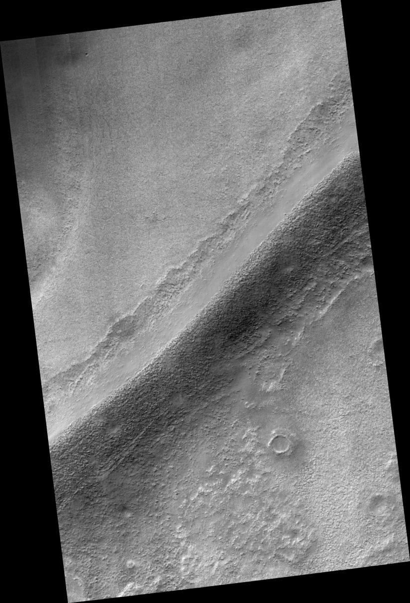
This HiRISE image covers a portion of a sinuous ridge on the floor of Argyre Basin in the southern hemisphere of Mars (55.0 degrees south, 319.2 east).
The ridge is one of a number of similar ridges that split and rejoin as they wind across the floor of the basin and around hills and mountains. It is unclear what process is responsible for formation of the ridges, but glacial, coastal, and fluvial processes have all been suggested.
For example, they may represent ancient coastal shorelines, sediments deposited in a river flowing under glacial ice, or an ancient river bed that has been left standing in relief as surrounding, probably finer grained sediments were subsequently eroded away.
The HiRISE image shows that the sediments forming the ridge include many large boulders that are often 1-2 meters or more in diameter. In addition, the sediments appear to occur in crude layers in a few locations. Such characteristics hold important clues to the process(es) responsible for formation of the ridge.
For example, if the ridge is the deposit formed by an ancient river then it may be difficult to account for the transport of so many large boulders.
Observation Geometry
Image PSP_001508_1245 was taken by the High Resolution Imaging Science Experiment (HiRISE) camera onboard the Mars Reconnaissance Orbiter spacecraft on 21-Nov-2006. The complete image is centered at -55.0 degrees latitude, 319.2 degrees East longitude. The range to the target site was 251.0 km (156.9 miles). At this distance the image scale is 50.2 cm/pixel (with 2 x 2 binning) so objects ~151 cm across are resolved. The image shown here has been map-projected to 50 cm/pixel and north is up. The image was taken at a local Mars time of 03:47 PM and the scene is illuminated from the west with a solar incidence angle of 86 degrees, thus the sun was about 4 degrees above the horizon. At a solar longitude of 138.9 degrees, the season on Mars is Northern Summer.
NASA's Jet Propulsion Laboratory, a division of the California Institute of Technology in Pasadena, manages the Mars Reconnaissance Orbiter for NASA's Science Mission Directorate, Washington. Lockheed Martin Space Systems, Denver, is the prime contractor for the project and built the spacecraft. The High Resolution Imaging Science Experiment is operated by the University of Arizona, Tucson, and the instrument was built by Ball Aerospace and Technology Corp., Boulder, Colo.
 Planetary Data System


