 | 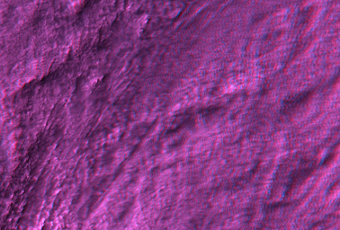 |
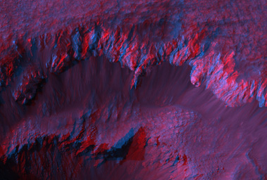
| Figure 1 | Figure 2 |
Ada Crater is a fresh (recently-formed) impact crater formed close to the southern edge of Meridiani Planum, far to the southeast of the Opportunity rover.
Shown here are two red-blue color anaglyphs in which you can view the topography with red-blue glasses (blue filter over your right eye). Figure 1 covers the crater and shows a relatively large area but with 3x reduction of spatial scale (75 cm/pixel). The crater looks extremely deep, but that impression is greatly exaggerated! We acquire stereo pairs with separation angles much greater than that of our own eyes, in order to extract for accurate measurements.
But the effect on color anaglyphs is to exaggerate the relief, which can be vertigo-inducing over steep terrain.
Figure 2 covers a portion of the ejecta blanket at full resolution. Here the vertical exaggeration is quite helpful to visualize the subtle undulations.
(We previously released image PSP_001348_1770, but acquired a later image (PSP_1678_1770) over this same area but from a different viewing angle to provide stereo coverage. See PIA09372.)
Observation GeometryImage PSP_001678_1770 was taken by the High Resolution Imaging Science Experiment (HiRISE) camera onboard the Mars Reconnaissance Orbiter spacecraft on 05-Dec-2006. The complete image is centered at -3.0 degrees latitude, 356.8 degrees East longitude. The range to the target site was 305.1 km (190.7 miles). At this distance the image scale is 30.5 cm/pixel (with 1 x 1 binning) so objects ~92 cm across are resolved. The image shown here has been map-projected to 25 cm/pixel and north is up. The image was taken at a local Mars time of 03:44 PM and the scene is illuminated from the west with a solar incidence angle of 58 degrees, thus the sun was about 32 degrees above the horizon. At a solar longitude of 145.6 degrees, the season on Mars is Northern Summer.
NASA's Jet Propulsion Laboratory, a division of the California Institute of Technology in Pasadena, manages the Mars Reconnaissance Orbiter for NASA's Science Mission Directorate, Washington. Lockheed Martin Space Systems, Denver, is the prime contractor for the project and built the spacecraft. The High Resolution Imaging Science Experiment is operated by the University of Arizona, Tucson, and the instrument was built by Ball Aerospace and Technology Corp., Boulder, Colo.
 Planetary Data System


