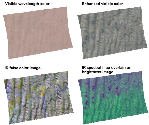
This image of frost-covered sand dunes in Richardson Crater in the south polar region of Mars was taken by the Compact Reconnaissance Imaging Spectrometer for Mars (CRISM) at 0504 UTC (12:04 a.m. EST) on Jan. 30, 2007, near 72.0 degrees south latitude, 179.4 degrees east longitude. CRISM's image was taken in 544 colors covering 0.36-3.92 micrometers, and shows features as small as 34 meters (111 feet) across. The region covered by the image is 10.2 kilometers (6.3 miles) wide. North is to the top, and the illumination is from the left.
Richardson Crater is well outside the south polar permanent cap, but is still covered by seasonal frost now at the beginning of southern spring. The frost is a mixture of water and carbon dioxide ices, and the processes by which the frosts sublimate are being investigated by MRO's instruments. The image shows a field of sand dunes inside the crater, with the sun just six degrees above the horizon. The four renderings of CRISM 544-color image highlight different aspects of the frosted dunes that can be brought out using different wavelength combinations.
The upper left image is constructed from visible wavelengths to approximate the dune's appearance to the human eye. The surface brightness is surprisingly uniform, because a large fraction of the sunlight illuminating the surface is scattered downward diffusely by the sky, washing out shadows. In the upper right image, the same view has been contrast-enhanced to accentuate both shading and small patches of sand that are visible on the dunes. Those patches are both darker and grayer than the frosted surface.
The lower left image is a false color composite constructed from 2.54, 1.43, and 1.16 micron wavelengths. Using this color combination, areas with the most carbon dioxide frost appear white to bluish, those with less appear yellowish, and those with the least appear as small, reddish spots. However even the reddish spots still have carbon dioxide frost on them, just less.
The lower right image is a spectral map draped over an image of surface brightness at 1.3 microns. Sand is colored red, water ice blue, and carbon dioxide frost green. Most areas appear blue-green because they have both water ice and carbon dioxide ice. The dark spots appear purple because they have both water ice (blue) and sand (red), with less carbon dioxide ice (green).
CRISM's mission: Find the spectral fingerprints of aqueous and hydrothermal deposits and map the geology, composition and stratigraphy of surface features. The instrument will also watch the seasonal variations in Martian dust and ice aerosols, and water content in surface materials -- leading to new understanding of the climate.
The Compact Reconnaissance Imaging Spectrometer for Mars (CRISM) is one of six science instruments on NASA's Mars Reconnaissance Orbiter. Led by The Johns Hopkins University Applied Physics Laboratory, the CRISM team includes expertise from universities, government agencies and small businesses in the United States and abroad.
 Planetary Data System


