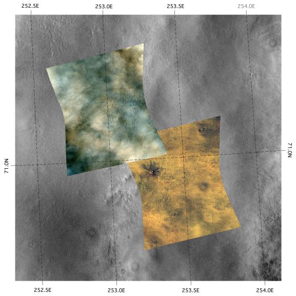
These two Compact Reconnaissance Imaging Spectrometer for Mars (CRISM) images were acquired over the northern plains of Mars near one of the possible landing sites for NASA's Phoenix mission, set to launch in August 2007. The lower right image was acquired first, on Nov. 29, 2006, at 0720 UTC (2:20 a.m. EST), while the upper left image was acquired about one month later on Dec. 26, 2006, at 0030 UTC (or Dec. 25, 2006, at 7:30 p.m. EST). The CRISM data were taken in 544 colors covering the wavelength range from 0.36-3.92 micrometers, and show features as small as about 20 meters (66 feet) across. The images shown above are red-green-blue color composites using wavelengths 0.71, 0.6, and 0.53 micrometers, respectively (or infrared, red, and green light), and are overlain on a mosaic of Mars Odyssey Thermal Emission Imaging System (THEMIS) visible data. Each image covers a region about 11 kilometers (6.6 miles) wide at its narrowest, and they overlap near 71.0 degrees north latitude, 252.8 degrees east longitude
The Earth equivalent to the season and latitude of this site is late summer in northern Canada, above the Arctic Circle. At that season and latitude, Martian weather conditions are transitioning from summer with generally clear skies, occasional weather fronts, and infrequent dust storms, to an autumn with pervasive, thick water-ice clouds.
The striking difference in the appearance of the images is caused by the seasonal development of water-ice clouds. The earlier (lower right) image is cloud-free, and surface features can clearly be seen - like the small crater in the upper left. However, the clouds and haze in the later (upper left) image make it hard to see the surface. There are variations in the thickness and spacing of the clouds, just like clouds on Earth. On other days when nearby sites were imaged, the cloud cover varied day-to-day, but as the seasons change the trend is more and thicker clouds.
With the onset of autumn the clouds will gradually cover the area and, just as with autumn on Earth, the Martian day is getting shorter at these high northern latitudes. In a few more months this area will settle into winter darkness and be covered in a layer of frost and carbon dioxide snow.
CRISM's mission: Find the spectral fingerprints of aqueous and hydrothermal deposits and map the geology, composition and stratigraphy of surface features. The instrument will also watch the seasonal variations in Martian dust and ice aerosols, and water content in surface materials -- leading to new understanding of the climate.
The Compact Reconnaissance Imaging Spectrometer for Mars (CRISM) is one of six science instruments on NASA's Mars Reconnaissance Orbiter. Led by The Johns Hopkins University Applied Physics Laboratory, the CRISM team includes expertise from universities, government agencies and small businesses in the United States and abroad.
 Planetary Data System


