PDS logoPlanetary Data System
PDS Information
Find a Node - Use these links to navigate to any of the 8 publicly accessible PDS Nodes.

This bar indicates that you are within the PDS enterprise which includes 6 science discipline nodes and 2 support nodes which are overseen by the Project Management Office at NASA's Goddard Space Flight Center (GSFC). Each node is led by an expert in the subject discipline, supported by an advisory group of other practitioners of that discipline, and subject to selection and approval under a regular NASA Research Announcement.
Click here to return to the Photojournal Home Page Click here to view a list of Photojournal Image Galleries Photojournal_inner_header
Latest Images  |  Spacecraft & Technology  |  Animations  |  Space Images App  |  Feedback  |  Photojournal Search  

PIA09026: New Impact Crater Formed Between April 2001 and December 2003
 Target Name:  Mars
 Is a satellite of:  Sol (our sun)
 Mission:  Mars Global Surveyor (MGS)
 Spacecraft:  Mars Global Surveyor Orbiter
 Instrument:  Mars Orbiter Camera (MOC)
 Product Size:  1227 x 1538 pixels (w x h)
 Produced By:  Malin Space Science Systems
 Producer ID:  MOC2-1617
 Full-Res TIFF:  PIA09026.tif (5.668 MB)
 Full-Res JPEG:  PIA09026.jpg (237.6 kB)

Click on the image above to download a moderately sized image in JPEG format (possibly reduced in size from original)

Original Caption Released with Image:

Click here for annotated figure 1 of PIA09026Click here for annotated figure 2 of PIA09026
Figure A
Annotated Image
No Annotation
Figure B
Annotated Image
No Annotation

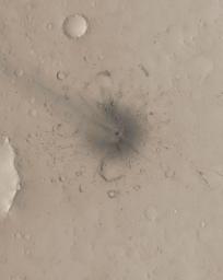
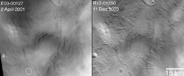
These Mars Global Surveyor (MGS) Mars Orbiter Camera (MOC) images show a young impact crater that formed in Arabia Terra near 22.2°N, 345.5°W, some time between 2 April 2001 and 11 December 2003.

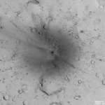
This image and figure A are sub-frames of MOC image S16-01199, acquired on 13 March 2006. This image has been colorized using a look-up table derived from color data acquired by the Mars Reconnaissance Orbiter's High Resolution Stereo Camera (HRSC). The site features a crater about 24.0 ± 3.0 meters (about 79 feet) across. In other words, one can compare a 100 yard U.S. style football field with this 26 yards wide crater. The "blast zone" around the crater is much larger and includes combination of rays and chains of small secondary impacts.

Figure B: This picture shows how the timing of the impact event was constrained. The first picture is a sub-frame of MOC red wide angle image E03-00127, obtained on 2 April 2001. The white circle indicates the impact site. The second picture, obtained after the impact occurred, is MOC red wide angle camera image R12-01350, acquired on 11 December 2003.

The Mars Global Surveyor mission is managed for NASA's Office of Space Science, Washington, by the Jet Propulsion Laboratory, a division of the California Institute of Technology, Pasadena. Lockheed Martin Space Systems, Denver, developed and operates the spacecraft. Malin Space Science Systems, San Diego, Calif., built and operates the Mars Orbiter Camera.

For more information about images from the Mars Orbiter Camera, see http://www.msss.com/mgs/moc/index.html.

Image Credit:
NASA/JPL/Malin Space Science Systems

Image Addition Date:
2006-12-06