Click on the image for full resolution
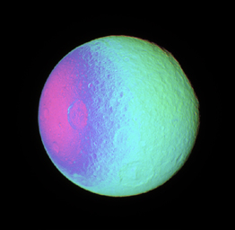
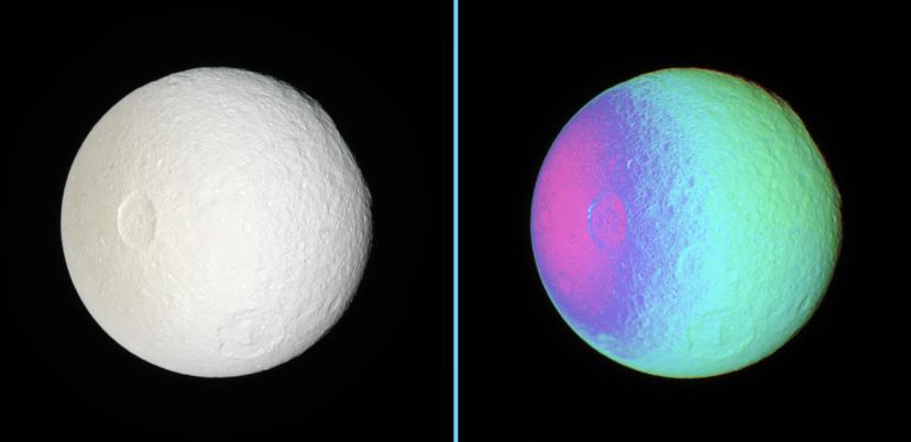
False Color View of Exposing Tethys' SurfaceThese side-by-side natural color and false-color views show cratered terrain on the anti-Saturn hemisphere of Tethys -- the side that always faces away from Saturn.
The rim of the immense impact basin of Odysseus (450 kilometers or 280 miles across) lies on the eastern limb, at the 2 o'clock position, making the limb there appear flatter than elsewhere. Other large craters seen here are Penelope (left of center) and Melanthius (below center).
The region between Penelope and Odysseus has not previously been imaged at such high resolution before.
The natural color view was created by compositing images taken using red, green and blue spectral filters.
To create the false-color view, ultraviolet, green and infrared images were combined into a single picture that isolates and maps regional color differences. This "color map" was then superimposed over a clear-filter image that preserves the relative brightness across the body.
The combination of color map and brightness image shows how colors vary across the surface of Tethys. The origin of the color differences is not yet understood, but may be caused by subtle differences in the surface composition or the sizes of grains making up the icy surface material.
North on Tethys (1,071 kilometers, or 665 miles across) is up.
The images were taken with the Cassini spacecraft narrow-angle camera on Dec. 31, 2006 at a distance of approximately 414,000 kilometers (257,000 miles) from Tethys. Image scale is 2 kilometers (2 miles) per pixel.
The Cassini-Huygens mission is a cooperative project of NASA, the European Space Agency and the Italian Space Agency. The Jet Propulsion Laboratory, a division of the California Institute of Technology in Pasadena, manages the mission for NASA's Science Mission Directorate, Washington, D.C. The Cassini orbiter and its two onboard cameras were designed, developed and assembled at JPL. The imaging operations center is based at the Space Science Institute in Boulder, Colo.
For more information about the Cassini-Huygens mission visit http://saturn.jpl.nasa.gov/home/index.cfm. The Cassini imaging team homepage is at http://ciclops.org.
 Planetary Data System


