PDS logoPlanetary Data System
PDS Information
Find a Node - Use these links to navigate to any of the 8 publicly accessible PDS Nodes.

This bar indicates that you are within the PDS enterprise which includes 6 science discipline nodes and 2 support nodes which are overseen by the Project Management Office at NASA's Goddard Space Flight Center (GSFC). Each node is led by an expert in the subject discipline, supported by an advisory group of other practitioners of that discipline, and subject to selection and approval under a regular NASA Research Announcement.
Click here to return to the Photojournal Home Page Click here to view a list of Photojournal Image Galleries Photojournal_inner_header
Latest Images  |  Spacecraft & Technology  |  Animations  |  Space Images App  |  Feedback  |  Photojournal Search  

PIA08811: Opportunity Traverse Map, 'Eagle' to 'Victoria'
 Target Name:  Mars
 Is a satellite of:  Sol (our sun)
 Mission:  Mars Global Surveyor (MGS)
Mars Exploration Rover (MER)
 Spacecraft:  Mars Global Surveyor Orbiter
Opportunity
 Instrument:  Mars Orbiter Camera (MOC)
 Product Size:  2485 x 2749 pixels (w x h)
 Produced By:  Malin Space Science Systems
 Full-Res TIFF:  PIA08811.tif (20.52 MB)
 Full-Res JPEG:  PIA08811.jpg (657.4 kB)

Click on the image above to download a moderately sized image in JPEG format (possibly reduced in size from original)

Original Caption Released with Image:

Click here for PIA08811 Annotated Image
Annotated Image

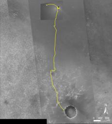
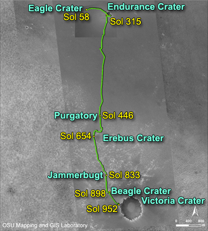
NASA's Mars Exploration Rover Opportunity reached the rim of "Victoria Crater" on Sept. 27, 2006, during the 951st Martian day, or sol, of the rover's work in the Meridian Planum region of Mars. Opportunity drove 9.28 kilometers (5.77 miles) in the explorations that took it from "Eagle Crater," where it landed in January 2004, eastward to "Endurance Crater," which it investigated for about half of 2004, then southward to Victoria.

This map of Opportunity's trek so far is overlaid onto images taken by the Mars Orbiter Camera on NASA's Mars Global Surveyor. Victoria is about 800 meters (one-half mile) in diameter, or about five times wider than Endurance and 40 times wider than Eagle. The scale bar at lower right shows the length of 800 meters (0.50 mile). North is up.

The Martian sol dates in the annotated image are as follows:
sol 58 was March 24, 2004
sol 315 was December 12, 2004
sol 446 was April 26, 2005
sol 654 was November 25, 2005
sol 833 was May 28, 2006
sol 898 was August 3, 2006
sol 952 was September 28, 2006

Image Credit:
NASA/JPL/MSSS/Ohio State University

Image Addition Date:
2006-10-06