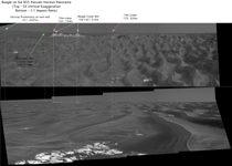
Figure 1This imagery from the panoramic camera on NASA's Mars Exploration Rover Opportunity shows the outcrop-rimmed "Beagle Crater" appearing on the horizon as Opportunity approaches it. The top version is vertically stretched to make horizon details easier to see. The lower version has normal proportions. The image is a mosaic of frames taken during Opportunity's 855th Martian day, or sol (June 20, 2006).
Beagle Crater is 35 meters (115 feet) in diameter. The Opportunity science and engineering teams hope to have the rover visit it on the way to "Victoria Crater." Beagle Crater was 310 meters (1,107 feet) away from Opportunity when this picture was taken. Even at this distance, blocks of ejecta can be seen around the prominent, raised rim of Beagle crater, suggesting that it may be among the youngest craters visited by Opportunity.
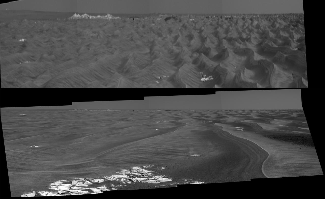
When scientists using orbital data calculated that they should be able to detect Victoria's rim in rover images, they scrutinized frames taken in the direction of the crater by the panoramic camera. To positively characterize the subtle horizon profile of the crater and some of the features leading up to it, researchers created this vertically-stretched image (top). The stretched image makes mild nearby dunes look like more threatening peaks, but that is only a result of the exaggerated vertical dimension. This vertical stretch technique was first applied to Viking Lander 2 panoramas by Philip Stooke, of the University of Western Ontario, Canada, to help locate the lander with respect to orbiter images. Vertically stretching the image allows features to be more readily identified by the Mars Exploration Rover science team. The bright white dot on the horizon near the upper left corner of the panorama, labeled "Outcrop Promontory," was thought to be a light-toned outcrop on the far wall of Victoria, based on a single azimuth measurement on sol 804 (April 28, 2006), suggesting that the rover was seeing over the low rim of Victoria. But comparing the azimuth angle of this feature in the sol 855 panorama and the angle of the same feature in the sol 804 panoramic image, PIA08447 (a process known as triangulation) revealed that this outcrop must instead be on the near rim of the crater.
The southeast rim of Victoria is labeled in bright green. The northeast rim is beyond the left edge of this panorama. The salmon-color lines and arrows highlight two small craters on the dark "annulus," or ring, around Victoria Crater.
 Planetary Data System


