PIA08543: A Peek into 'Alamogordo Creek'
 Target Name:  Mars
 Is a satellite of:  Sol (our sun)
 Mission:  Mars Exploration Rover (MER)
 Spacecraft:  Opportunity
 Instrument:  Microscopic Imager
Panoramic Camera 
 Product Size:  2116 x 1846 pixels (w x h)
 Produced By:  Cornell University 
 Full-Res TIFF:  PIA08543.tif (11.73 MB)
 Full-Res JPEG:  PIA08543.jpg (535.4 kB)

Click on the image above to download a moderately sized image in JPEG format (possibly reduced in size from original)

Original Caption Released with Image:

figure 1 for PIA08543figure 2 for PIA08543figure 3 for PIA08543
Figure 1Figure 2Figure 3

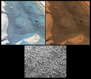
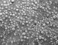
On its 825th Martian day (May 20, 2006), NASA's Mars Exploration Rover Opportunity stopped for the weekend to place its instrument arm onto the soil target pictured here, dubbed "Alamogordo Creek." Two views from the panoramic camera, acquired at about noon local solar time, are at the top. Below them is a close-up view from the microscopic imager.

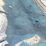
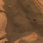
At upper left, a false-color view emphasizes differences among materials in rocks and soil. It combines images taken through the panoramic camera's 753-nanometer, 535-nanometer and 432-nanometer filters. At upper right is an approximately true-color rendering made with the panoramic camera's 600-nanometer, 535-nanometer and 480-nanometer filters. The microscopic-imager frame covers the area outlined by the white boxes in the panoramic-camera views, a rectangle 3 centimeters (1.2 inches) across.

As Opportunity traverses to the south, it is analyzing soil and rocks along the way for differences from those seen earlier. At this site, the soil contains abundant small spherical fragments, thought to be hematite-rich concretions, plus finer-grained basaltic sand. Most of the spherical fragments seen in the microscopic image are smaller than those first seen at the rover's landing site in "Eagle Crater," some five kilometers (3.1 miles) to the north. However, a few larger spherical fragments and other rock fragments can also be seen in the panoramic-camera images.

Image Credit:
NASA/JPL/Cornell/USGS

Image Addition Date:
2006-06-15