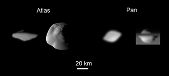
Annotated VersionShown here are the highest resolution images of the moons Pan and Atlas, showing their distinctive "flying saucer" shapes, owing to equatorial ridges not seen on the other moons of Saturn.
From left to right: a view of Atlas' trailing hemisphere, with north up, at a spatial scale of about 1 kilometer (0.6 mile) per pixel; Atlas seen at about 250 meters (820 feet) per pixel from mid-southern latitudes, with the sub-Saturn hemisphere at the top and leading hemisphere to the left; Pan's trailing hemisphere seen at about 3 kilometers (2 miles) per pixel from low southern latitudes; an equatorial view, with Saturn in the background, of Pan's anti-Saturn hemisphere at about 1 kilometer (0.6 mile) per pixel.
On Atlas, the ridge extends 20 to 30 degrees in latitude on either side of the equator; on Pan, its latitudinal extent is 15 to 20 degrees. Atlas shows more asymmetry than Pan in having a more rounded ridge in the leading and sub-Saturn quadrants.
The heights of the ridges can be crudely estimated by assuming (ellipsoidal) shapes that lack ridges and vary smoothly cross the equator. Heights of Atlas' ridge range from about 3 kilometers (2 miles) at 270 degrees west longitude to 5 kilometers (3 miles) at 180 and 0 degrees. Pan's ridge reaches about 4 kilometers (2.5 miles) at 0 degrees west longitude, and is about 1.5 kilometers (0.9 mile) high over most of the rest of the equator.
The ridges represent about 27 percent of Atlas' volume and 10 percent of Pan's volume.
The images were acquired with the Cassini spacecraft narrow-angle camera between 2005 and 2007. Pan is 33 kilometers (20.5 miles) across at its equator and 21 kilometers (13 miles) across at its poles; Atlas is 39 kilometers (24 miles) across at its equator and 18 kilometers (11 miles) across at its poles.
The Cassini-Huygens mission is a cooperative project of NASA, the European Space Agency and the Italian Space Agency. The Jet Propulsion Laboratory, a division of the California Institute of Technology in Pasadena, manages the mission for NASA's Science Mission Directorate, Washington, D.C. The Cassini orbiter and its two onboard cameras were designed, developed and assembled at JPL. The imaging operations center is based at the Space Science Institute in Boulder, Colo.
For more information about the Cassini-Huygens mission visit http://saturn.jpl.nasa.gov/home/index.cfm. The Cassini imaging team homepage is at http://ciclops.org.
 Planetary Data System


