PDS logoPlanetary Data System
PDS Information
Find a Node - Use these links to navigate to any of the 8 publicly accessible PDS Nodes.

This bar indicates that you are within the PDS enterprise which includes 6 science discipline nodes and 2 support nodes which are overseen by the Project Management Office at NASA's Goddard Space Flight Center (GSFC). Each node is led by an expert in the subject discipline, supported by an advisory group of other practitioners of that discipline, and subject to selection and approval under a regular NASA Research Announcement.
Click here to return to the Photojournal Home Page Click here to view a list of Photojournal Image Galleries Photojournal_inner_header
Latest Images  |  Spacecraft & Technology  |  Animations  |  Space Images App  |  Feedback  |  Photojournal Search  

PIA08236: Eroded Moon
 Target Name:  Hyperion
 Is a satellite of:  Saturn
 Mission:  Cassini-Huygens
 Spacecraft:  Cassini Orbiter
 Instrument:  ISS - Narrow Angle
 Product Size:  317 x 305 pixels (w x h)
 Produced By:  Cassini Imaging Team
 Primary Data Set:  Cassini
 Full-Res TIFF:  PIA08236.tif (290.6 kB)
 Full-Res JPEG:  PIA08236.jpg (9.515 kB)

Click on the image above to download a moderately sized image in JPEG format (possibly reduced in size from original)

Original Caption Released with Image:

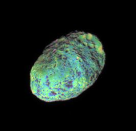
This extreme false-color view of Hyperion shows color variation across the impact-blasted surface of the tumbling moon.

To create this false-color view, ultraviolet, green and infrared images were combined into a single picture that isolates and maps regional color differences. This "color map" was then superposed over a clear-filter image that preserves the relative brightness across the body.

The combination of the color map and brightness image shows how colors vary across Hyperion's surface in relation to geologic features. The origin of the color differences is not yet understood, but may be caused by subtle differences in the surface composition or the sizes of grains making up the icy surface material on Hyperion (280 kilometers, or 174 miles across).

The images used to create this view were acquired using the Cassini spacecraft narrow-angle camera on June 28, 2006 at a distance of approximately 294,000 kilometers (183,000 miles) from Hyperion. Image scale is 2 kilometers (1 mile) per pixel.

The Cassini-Huygens mission is a cooperative project of NASA, the European Space Agency and the Italian Space Agency. The Jet Propulsion Laboratory, a division of the California Institute of Technology in Pasadena, manages the mission for NASA's Science Mission Directorate, Washington, D.C. The Cassini orbiter and its two onboard cameras were designed, developed and assembled at JPL. The imaging operations center is based at the Space Science Institute in Boulder, Colo.

For more information about the Cassini-Huygens mission visit http://saturn.jpl.nasa.gov/home/index.cfm. The Cassini imaging team homepage is at http://ciclops.org.

Image Credit:
NASA/JPL/Space Science Institute

Image Addition Date:
2006-08-04