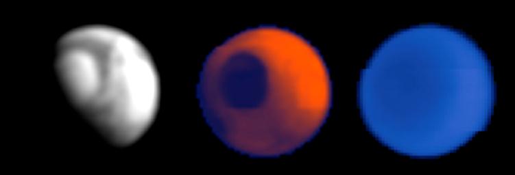
The Mars Climate Sounder, an instrument on NASA's Mars Reconnaissance Orbiter designed to monitor daily changes in the global atmosphere of Mars, made its first observations of Mars on March 24, 2006.
These tests were conducted to demonstrate that the instrument could, if needed, support the mission's aerobraking maneuvers (dips into the atmosphere to change the shape of the orbit) by providing hemisphere-scale coverage of atmospheric activity. The instrument scanned nine arrays of detectors four times across the entire disc of the planet, including the north pole, from an altitude of about 45,000 kilometers (28,000 miles). This is about 150 times farther away than the spacecraft will be during its main science phase. At this great range, the planet appears only 40 pixels wide, as suggested by the pixilation of the images. However, this is sufficient to identify regional dust storms in the lower atmosphere. Regional dust storms could perturb atmospheric densities at the higher altitudes (about 100 kilometers or 60 miles) where the orbiter will conduct more than 500 aerobraking passes during the next six months. Such storms are rare in the current season on Mars, early northern spring, and no large storms are present as the orbiter prepares for the start of aerobraking.
Each of the Mars Climate Sounder's arrays looks in a different wavelength band, and three of the resulting images are shown here. The view on the left is from data collected in a broad spectral band (wavelengths of 0.3 microns to 3 microns) for reflected sunlight. The view in the center is from data collected in the 12-micron thermal-infrared band. This band was chosen to sense infrared radiation from the surface when the atmosphere is clear and from dust clouds when it is not. The view on the right is from data collected at 15 microns, a longer-wavelength band still in the thermal-infrared part of the spectrum. At this wavelength, carbon dioxide, the main ingredient in Mars' atmosphere, hides the surface emission, and the thermal-infrared radiation comes only from the atmosphere.
The visible-and-near-infrared image (left) is bright where surface ice and atmospheric hazes reflect sunlight back to space. The view is of the northern half of Mars, with the north polar cap visible as the bright semicircle at upper left. The night half of the planet (lower left) is dark. The "terminator" boundary between the day side and night side of the planet cuts from lower left to upper right, through the polar area. During the science phase of the mission, after the spacecraft has shrunk its orbit to a nearly circular loop approximately 300 kilometers (186 miles) above the surface, these visible-and-near-infrared readings by the Mars Climate Sounder will track how the amount of solar energy reflected from Mars varies from place-to-place and season-to-season, particularly in the polar regions where absorbed sunlight vaporizes the seasonal carbon-dioxide ice.
The 12-micron image (center) indicates that heat is being emitted from both the day side and the night side of the planet. The polar cap is dark in this image because it is cold (minus 190 degrees Fahrenheit) and emits less heat than surrounding areas. During the science phase of the mission, the thermal-infrared readings at this wavelength by Mars Climate Sounder will be used to track dust and clouds in the atmosphere. In the current season on Mars, the atmosphere is relatively clear except for an equatorial belt of thin water-ice clouds present in the visible-and-near-infrared image, and so the 12-micron image is dominated by the infrared radiation from the surface on the relatively hot dayside (upper right).
The 15-micron image (right) indicates the temperatures of the atmosphere at an altitude of about 25 kilometers (15 miles), where there is not much temperature difference even between the night side and the day side of the planet. The polar atmosphere is colder, so it appears darker.
Once deployed in a low-altitude, nearly circular orbit next fall, the Mars Climate Sounder will systematically alternate views of the surface with views of the atmosphere above the limb (horizon) of the planet from the surface to an altitude of 80 kilometers (50 miles), with a vertical resolution of 5 kilometers (3 miles). In this way it will monitor atmospheric and surface changes through a full annual cycle to characterize the present climate of Mars.
The Mars Climate Sounder was provided by NASA's Jet Propulsion Laboratory, Pasadena, Calif., which also manages the Mars Reconnaissance Orbiter mission for the NASA Science Mission Directorate.

 Planetary Data System


