PDS logoPlanetary Data System
PDS Information
Find a Node - Use these links to navigate to any of the 8 publicly accessible PDS Nodes.

This bar indicates that you are within the PDS enterprise which includes 6 science discipline nodes and 2 support nodes which are overseen by the Project Management Office at NASA's Goddard Space Flight Center (GSFC). Each node is led by an expert in the subject discipline, supported by an advisory group of other practitioners of that discipline, and subject to selection and approval under a regular NASA Research Announcement.
Click here to return to the Photojournal Home Page Click here to view a list of Photojournal Image Galleries Photojournal_inner_header
Latest Images  |  Spacecraft & Technology  |  Animations  |  Space Images App  |  Feedback  |  Photojournal Search  

PIA07993: Olivine-Rich Bedrock Around Nili Fossae
 Target Name:  Mars
 Is a satellite of:  Sol (our sun)
 Mission:  2001 Mars Odyssey
 Spacecraft:  2001 Mars Odyssey
 Instrument:  THEMIS
 Product Size:  2400 x 2550 pixels (w x h)
 Produced By:  Arizona State University
 Full-Res TIFF:  PIA07993.tif (18.38 MB)
 Full-Res JPEG:  PIA07993.jpg (971.5 kB)

Click on the image above to download a moderately sized image in JPEG format (possibly reduced in size from original)

Original Caption Released with Image:

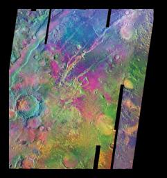
Colors indicate infrared emission signatures in this mosaic of images from NASA's Mars Odyssey orbiter of a region of martian troughs named Nili Fossae. Analysis of this information from Odyssey's Thermal Emission Imaging System suggests that a deposit rich in the mineral olivine is about four times larger than indicated in earlier data from a lower-resolution infrared instrument on NASA's Mars Global Surveyor. The olivine-rich exposures appear magenta to purple-blue in this color-coding.

Olivine can turn into other minerals rapidly in the presence of water. This deposit, in a relatively old region of Mars' surface adjacent to one of the planet's largest volcanoes, Syrtis Major, suggests the region may never have seen much water.

The mosaic covers most of an area about 380 kilometers (about 240 miles) wide, from 75 degrees to 81 degrees in east longitude and from 18 degrees to 25 degrees in north latitude. North is up. Emission intensities at infrared wavelengths of 12.57 microns, 11.04 microns and 9.35 microns are displayed in red, green and blue, respectively.

This mosaic was presented in a report in the June 2005 issue of the journal Geology. For additional information about that report, see a University of Hawaii press release http://www.soest.hawaii.edu/SOEST_News/News/PressReleases/Hamilton/.

Image Credit:
NASA/JPL/ASU

Image Addition Date:
2005-06-02