PDS logoPlanetary Data System
PDS Information
Find a Node - Use these links to navigate to any of the 8 publicly accessible PDS Nodes.

This bar indicates that you are within the PDS enterprise which includes 6 science discipline nodes and 2 support nodes which are overseen by the Project Management Office at NASA's Goddard Space Flight Center (GSFC). Each node is led by an expert in the subject discipline, supported by an advisory group of other practitioners of that discipline, and subject to selection and approval under a regular NASA Research Announcement.
Click here to return to the Photojournal Home Page Click here to view a list of Photojournal Image Galleries Photojournal_inner_header
Latest Images  |  Spacecraft & Technology  |  Animations  |  Space Images App  |  Feedback  |  Photojournal Search  

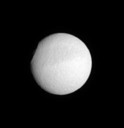
PIA07589: Profile of Odysseus
 Target Name:  Tethys
 Is a satellite of:  Saturn
 Mission:  Cassini-Huygens
 Spacecraft:  Cassini Orbiter
 Instrument:  ISS - Narrow Angle
 Product Size:  271 x 280 pixels (w x h)
 Produced By:  Cassini Imaging Team
 Primary Data Set:  Cassini
 Full-Res TIFF:  PIA07589.tif (76.19 kB)
 Full-Res JPEG:  PIA07589.jpg (3.245 kB)

Click on the image above to download a moderately sized image in JPEG format (possibly reduced in size from original)

Original Caption Released with Image:

The profile of the 450-kilometer-wide (280-mile) crater Odysseus makes this image look as if someone sliced off a chunk of Tethys (1,071 kilometers, or 665 miles across). According to measurements made in Voyager images, the crater rim rises to about 5 kilometers (3 miles) above the surrounding terrain.

This view shows territory eastward of a previously released Cassini view that looked more directly into the giant impact basin (see PIA07557). The moon's equatorial dark band can be seen here as well.

This view shows principally the southern leading hemisphere of Tethys. North is up and rotated 10 degrees to the left.

The image was taken in visible light with the Cassini spacecraft narrow-angle camera on July 31, 2005, at a distance of approximately 1.3 million kilometers (800,000 miles) from Tethys and at a Sun-Tethys-spacecraft, or phase, angle of 18 degrees. The image scale is 8 kilometers (5 miles) per pixel.

The Cassini-Huygens mission is a cooperative project of NASA, the European Space Agency and the Italian Space Agency. The Jet Propulsion Laboratory, a division of the California Institute of Technology in Pasadena, manages the mission for NASA's Science Mission Directorate, Washington, D.C. The Cassini orbiter and its two onboard cameras were designed, developed and assembled at JPL. The imaging operations center is based at the Space Science Institute in Boulder, Colo.

For more information about the Cassini-Huygens mission visit http://saturn.jpl.nasa.gov. For additional images visit the Cassini imaging team homepage http://ciclops.org.

Image Credit:
NASA/JPL/Space Science Institute

Image Addition Date:
2005-09-19