11 November 2004
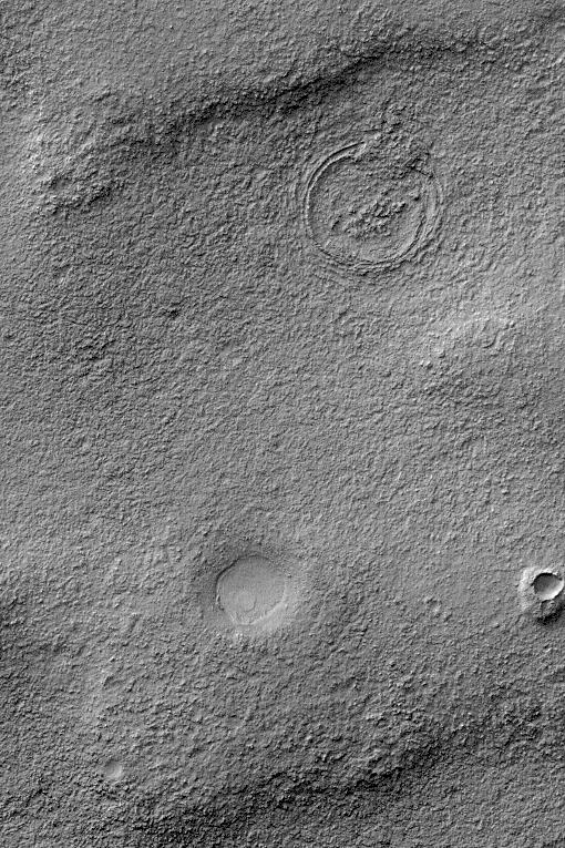
This Mars Global Surveyor (MGS) Mars Orbiter Camera (MOC) image captures some of the complexity of the martian upper crust. Mars does not simply have an impact-cratered surface, its upper crust is a cratered volume. Over time, older craters on Mars have been eroded, filled, buried, and in some cases exhumed and re-exposed at the martian surface. The crust of Mars is layered to depths of 10 or more kilometers, and mixed in with the layered bedrock are a variety of ancient craters with diameters ranging from a few tens of meters (a few tens of yards) to several hundred kilometers (more than one or two hundred miles).
The picture shown here captures some of the essence of the layered, cratered volume of the upper crust of Mars in a very simple form. The image shows three distinct circular features. The smallest, in the lower right quarter of the image, is a meteor crater surrounded by a mound of material. This small crater formed within a layer of bedrock that once covered the entire scene, but today is found only in this small remnant adjacent to the crater. The intermediate-sized crater, west (left) of the small one, formed either in the next layer down--that is, below the layer in which the small crater formed--or it formed in some layers that are now removed, but was big enough to penetrate deeply into the rock that is near the surface today. The largest circular feature in the image, in the upper right quarter of the image, is still largely buried. It formed in layers of rock that are below the present surface. Erosion has brought traces of its rim back to the surface of Mars. This picture is located near 50.0°S, 77.8°W, and covers an area approximately 3 km (1.9 mi) across. Sunlight illuminates this October 2004 image from the upper left.
