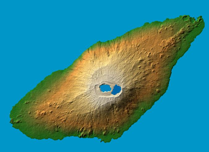
The recently active volcano Mt. Manaro is the dominant feature in this shaded relief image of Ambae Island, part of the Vanuatu archipelago located 1400 miles northeast of Sydney, Australia. About 5000 inhabitants, half the island's population, were evacuated in early December from the path of a possible lahar, or mud flow, when the volcano started spewing clouds of steam and toxic gases 10,000 feet into the atmosphere.
Last active in 1996, the 1496 meter (4908 ft.) high Hawaiian-style basaltic shield volcano features two lakes within its summit caldera, or crater. The ash and gas plume is actually emerging from a vent at the center of Lake Voui (at left), which was formed approximately 425 years ago after an explosive eruption.
Two visualization methods were combined to produce the image: shading and color coding of topographic height. The shade image was derived by computing topographic slope in the northwest-southeast direction, so that northwest slopes appear bright and southeast slopes appear dark. Color coding is directly related to topographic height, with green at the lower elevations, rising through yellow and tan, to white at the highest elevations.
Elevation data used in this image were acquired by the Shuttle Radar Topography Mission aboard the Space Shuttle Endeavour, launched on Feb. 11, 2000. SRTM used the same radar instrument that comprised the Spaceborne Imaging Radar-C/X-Band Synthetic Aperture Radar (SIR-C/X-SAR) that flew twice on the Space Shuttle Endeavour in 1994. SRTM was designed to collect 3-D measurements of the Earth's surface. To collect the 3-D data, engineers added a 60-meter (approximately 200-foot) mast, installed additional C-band and X-band antennas, and improved tracking and navigation devices. The mission is a cooperative project between NASA, the National Geospatial-Intelligence Agency (NGA) of the U.S. Department of Defense and the German and Italian space agencies. It is managed by NASA's Jet Propulsion Laboratory, Pasadena, Calif., for NASA's Earth Science Enterprise,Washington, D.C.
Location: 15.4 degree south latitude, 167.9 degrees east longitude
Orientation: North toward the top, Mercator projection
Size: 36.8 by 27.8 kilometers (22.9 by 17.3 miles)
Image Data: shaded and colored SRTM elevation model
Date Acquired: February 2000
 Planetary Data System


