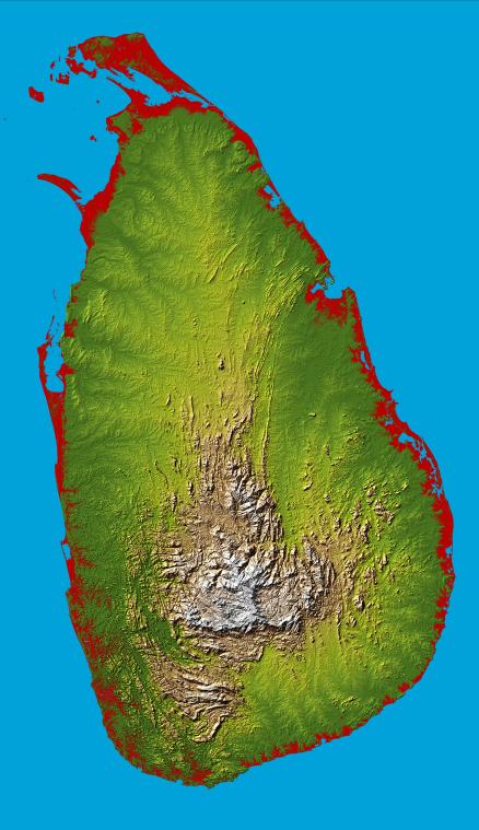
The topography of the island nation of Sri Lanka is well shown in this color-coded shaded relief map generated with digital elevation data from the Shuttle Radar Topography Mission (SRTM).
Two visualization methods were combined to produce the image: shading and color coding of topographic height. The shade image was derived by computing topographic slope in the northwest-southeast direction, so that northwest slopes appear bright and southeast slopes appear dark. Color coding is directly related to topographic height, with green at the lower elevations, rising through yellow and tan, to white at the highest elevations.
For this special view heights below 10 meters (33 feet) above sea level have been colored red. These low coastal elevations extend 5 to 10 km (3.1 to 6.2 mi) inland on Sri Lanka and are especially vulnerable to flooding associated with storm surges, rising sea level, or, as in the aftermath of the earthquake of December 26, 2004, tsunami. These so-called tidal waves have occurred numerous times in history and can be especially destructive, but with the advent of the near-global SRTM elevation data planners can better predict which areas are in the most danger and help develop mitigation plans in the event of particular flood events.
Sri Lanka is shaped like a giant teardrop falling from the southern tip of the vast Indian subcontinent. It is separated from India by the 50km (31mi) wide Palk Strait, although there is a series of stepping-stone coral islets known as Adam's Bridge that almost form a land bridge between the two countries. The island is just 350km (217mi) long and only 180km (112mi) wide at its broadest, and is about the same size as Ireland, West Virginia or Tasmania.
The southern half of the island is dominated by beautiful and rugged hill country, and includes Mt Pidurutalagala, the island's highest point at 2524 meters (8281 ft). The entire northern half comprises a large plain extending from the edge of the hill country to the Jaffna peninsula.
Elevation data used in this image were acquired by the Shuttle Radar Topography Mission aboard the Space Shuttle Endeavour, launched on Feb. 11, 2000. SRTM used the same radar instrument that comprised the Spaceborne Imaging Radar-C/X-Band Synthetic Aperture Radar (SIR-C/X-SAR) that flew twice on the Space Shuttle Endeavour in 1994. SRTM was designed to collect 3-D measurements of the Earth's surface. To collect the 3-D data, engineers added a 60-meter (approximately 200-foot) mast, installed additional C-band and X-band antennas, and improved tracking and navigation devices. The mission is a cooperative project between NASA, the National Geospatial-Intelligence Agency (NGA) of the U.S. Department of Defense and the German and Italian space agencies. It is managed by NASA's Jet Propulsion Laboratory, Pasadena, Calif., for NASA's Earth Science Enterprise,Washington, D.C.
Location: 8.0 degrees North latitude, 80.7 degrees East longitude
Orientation: North toward the top, Mercator projection
Size: 275.6 by 482.4 kilometers (165.4 by 299.0 miles)
Image Data: shaded and colored SRTM elevation model
Date Acquired: February 2000
 Planetary Data System


