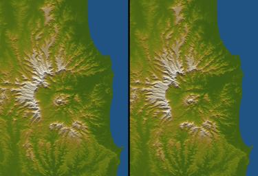
Figure 1Australia is the only continent without any current volcanic activity, but it hosts one of the world's largest extinct volcanoes, the Tweed Volcano. Rock dating methods indicate that eruptions here lasted about three million years, ending about 20 million years ago. Twenty million years of erosion has left this landform deeply eroded yet very recognizable, appearing as a caldera with a central peak. The central peak is not an old remnant landform but is instead the erosional stub of the volcanic neck (the central pipe that carried the magma upward). It is surrounded by ring dikes, which are circular sheets of magma that solidified and now form erosion-resistant ridges. The central peak is named Mount Warning.Topography plays a central role in envisioning the volcano at its climax and in deciphering the landscape evolution that has occurred since then. Low-relief uplands interspersed between deeply eroded canyons form a radial pattern that clearly defines the shape and extent of the original volcanic dome. Erosion is most extensive on the eastern side because the eroding streams drained directly to the ocean and therefore had the steepest gradients. This asymmetry of erosion has been extreme enough that the volcano has been hollowed out by the east-flowing drainage, forming an "erosional caldera." Calderas usually form as the result of collapse where magmas retreat within an active volcano. If collapse occurred here, erosion may have removed the evidence, but it produced a similar landform itself.
Three visualization methods were combined to produce this image: shading, color coding, and synthetic stereoscopy. The shade image was derived by computing topographic slope in the north-south direction. Northern slopes appear bright and southern slopes appear dark. Color coding is directly related to topographic height, with green at the lower elevations, rising through yellow and tan, to white at the highest elevations. The stereoscopic effect was then created by generating two differing perspectives, one for each eye (see Figure 1). The image can be seen in 3-D by viewing the left image with the right eye and the right image with the left eye (cross-eyed viewing) or by downloading, printing, and splitting the image pair and viewing them with a stereoscope. When stereoscopically merged, the result is a vertically exaggerated view of Earth's surface in its full three dimensions. Elevations range from sea level (shown in blue) to about 1340 meters (4400 feet) along the northwest caldera rim.
Elevation data used in this image were acquired by the Shuttle Radar Topography Mission aboard the Space Shuttle Endeavour, launched on Feb. 11, 2000. SRTM used the same radar instrument that comprised the Spaceborne Imaging Radar-C/X-Band Synthetic Aperture Radar (SIR-C/X-SAR) that flew twice on the Space Shuttle Endeavour in 1994. SRTM was designed to collect 3-D measurements of the Earth's surface. To collect the 3-D data, engineers added a 60-meter (approximately 200-foot) mast, installed additional C-band and X-band antennas, and improved tracking and navigation devices. The mission is a cooperative project between NASA, the National Geospatial-Intelligence Agency (NGA) of the U.S. Department of Defense and the German and Italian space agencies. It is managed by NASA's Jet Propulsion Laboratory, Pasadena, Calif., for NASA's Earth Science Enterprise, Washington, D.C.
Size: 102 kilometers (63 miles) by 74 kilometers (46 miles)
Location: 28.4 degrees South latitude, 153.3 degrees East longitude
Orientation: North toward the top, cylindrical projection
Image Data: Shaded and colored SRTM elevation model
Date Acquired: February 2000

 Planetary Data System


