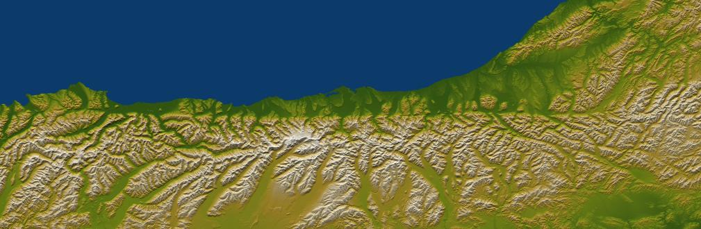
The Alpine fault runs parallel to, and just inland of, much of the west coast of New Zealand's South Island. This view was created from the near-global digital elevation model produced by the Shuttle Radar Topography Mission (SRTM) and is almost 500 kilometers (just over 300 miles) wide. Northwest is toward the top. The fault is extremely distinct in the topographic pattern, nearly slicing this scene in half lengthwise.
In a regional context, the Alpine fault is part of a system of faults that connects a west dipping subduction zone to the northeast with an east dipping subduction zone to the southwest, both of which occur along the juncture of the Indo-Australian and Pacific tectonic plates. Thus, the fault itself constitutes the major surface manifestation of the plate boundary here. Offsets of streams and ridges evident in the field, and in this view of SRTM data, indicate right-lateral fault motion. But convergence also occurs across the fault, and this causes the continued uplift of the Southern Alps, New Zealand's largest mountain range, along the southeast side of the fault.
Two visualization methods were combined to produce this image: shading and color coding of topographic height. The shade image was derived by computing topographic slope in the northwest-southeast (image top to bottom) direction, so that northwest slopes appear bright and southeast slopes appear dark. Color coding is directly related to topographic height, with green at the lower elevations, rising through yellow and tan, to white at the highest elevations.
Elevation data used in this image were acquired by the Shuttle Radar Topography Mission aboard the Space Shuttle Endeavour, launched on Feb. 11, 2000. SRTM used the same radar instrument that comprised the Spaceborne Imaging Radar-C/X-Band Synthetic Aperture Radar (SIR-C/X-SAR) that flew twice on the Space Shuttle Endeavour in 1994. SRTM was designed to collect 3-D measurements of the Earth's surface. To collect the 3-D data, engineers added a 60-meter (approximately 200-foot) mast, installed additional C-band and X-band antennas, and improved tracking and navigation devices. The mission is a cooperative project between NASA, the National Geospatial-Intelligence Agency (NGA) of the U.S. Department of Defense and the German and Italian space agencies. It is managed by NASA's Jet Propulsion Laboratory, Pasadena, Calif., for NASA's Earth Science Enterprise, Washington, D.C.
Size: 495 kilometers (307 miles) by 162 kilometers (100 miles)
Location: 43.2 degrees South latitude, 170.5 degrees East longitude
Orientation: Northwest toward the top
Image Data: Shaded and colored SRTM elevation model
Date Acquired: February 2000
 Planetary Data System


