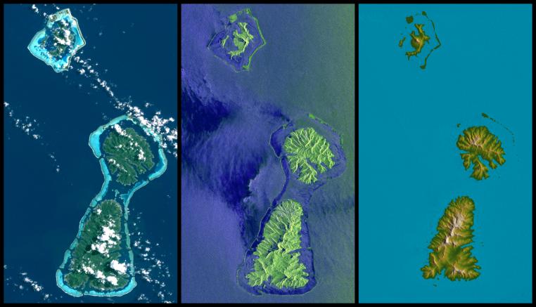
Bora Bora, Tahaa, and Raiatea (top to bottom) are Polynesian Islands about 220 kilometers (135 miles) west-northwest of Tahiti in the South Pacific. Each of the islands is surrounded by a coral reef and its associated islets ("motus") that enclose a lagoon. Actually, as seen here, Tahaa and Raiatea are close enough together to share a common lagoon and reef. These islands are volcanic in origin and were built up from the sea floor by lava extrusions millions of years ago. None is now active, and all are deeply eroded.
This display compares three differing "views from space" of these islands. On the left, an image from the Landsat 7 satellite shows the islands as they might have appeared to an astronaut in orbit in 1999 (but a little sharper and with atmospheric haze suppressed). In the middle is an image created from data gathered by the third-generation Shuttle Imaging Radar (SIR-C), flown in 1994. On the right is a graphic illustrating elevation data gathered by the Shuttle Radar Topography Mission (SRTM) in 2000.
Each of these images shows very different information as compared to the other two. Landsat sees clouds, which are almost always above these islands, blocking the view of the terrain. It also readily sees through shallow water down to the reefs. SIR-C sees the waves and other effects of winds upon the ocean surface. It does not look through water to see the reefs, but it clearly separates land and water. It also provides a bolder (but distorted) view of the islands' topographic patterns. With the ability of radar to see through clouds and provision of its own illumination, the SIR-C view is not limited by clouds nor their shadows.
SRTM was designed to provide new information that is missing in the Landsat and SIR-C views. Specifically, SRTM created the world's first near-global, detailed elevation model. Natural topographic shading in Landsat imagery and radar topographic shadowing of SIR-C give some evidence of the shape of the ground but do not actually measure topographic height. They therefore have not fully characterized the three-dimensional shape of landforms. The shape and height of Earth's landforms affects nearly every natural process and human activity that occurs at Earth's surface, including vegetative growth, water supply, transportation, and radio communication. Thus, the new information provided by SRTM is highly valuable in understanding and interacting with our environment. The Landsat image is an enhanced display of natural visible color (Landsat bands 1,2,3 in blue, green, red). As is evident from the cloud shadows, the morning sun shines from the northeast (upper right).
The SIR-C image displays the L-band radar data (23.5 centimeter wavelength, vertical transmit and receive) in red, C-band radar data (5.8 centimeter wavelength, vertical transmit and receive) in green, and a difference of the two (L minus C) in blue. Cosmetic color adjustments were used to enhance the green and blue display of land and water. The "side-looking" transmitted radar illumination was from the northeast as the Space Shuttle Endeavour passed from northwest to southeast on a descending orbit.
Two visualization methods were combined to produce the SRTM image: color coding of topographic height plus shading of the topographic model. Color coding is directly related to topographic height, with green at the lower elevations, rising through yellow and tan, to white at the highest elevations. Shading was derived by computing topographic slope in the northeast-southwest direction, so that northeast slopes appear bright and southwest slopes appear dark, generally consistent with the Landsat and SIR-C illumination directions.
Elevation data used in this image were acquired by the Shuttle Radar Topography Mission aboard the Space Shuttle Endeavour, launched on Feb. 11, 2000. SRTM used the same radar instrument that comprised the Spaceborne Imaging Radar-C/X-Band Synthetic Aperture Radar (SIR-C/X-SAR) that flew twice on the Space Shuttle Endeavour in 1994. SRTM was designed to collect 3-D measurements of the Earth's surface. To collect the 3-D data, engineers added a 60-meter (approximately 200-foot) mast, installed additional C-band and X-band antennas, and improved tracking and navigation devices. The mission is a cooperative project between NASA, the National Geospatial-Intelligence Agency (NGA) of the U.S. Department of Defense and the German and Italian space agencies. It is managed by NASA's Jet Propulsion Laboratory, Pasadena, Calif., for NASA's Earth Science Enterprise, Washington, D.C.
Size: 73 kilometers (45 miles) by 42 kilometers (26 miles)
Location: 16.7 degrees South latitude, 151.5 degrees West longitude
Orientation: North toward the top right
Image Data: Landsat (left), SIR-C (middle), shaded and colored SRTM elevation (right)
Date Acquired: July 20, 1999 (Landsat), October 1994 (SIR-C), February 2000 (SRTM)
 Planetary Data System


