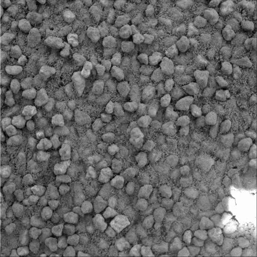
A basic tenet of sedimentology, the field of geology that studies sedimentary processes, is that the farther a piece of rock travels from its source, the smaller and rounder in shape it becomes as the materials suffer impacts with other grains during transport by wind or water. Grains that have not traveled as far are more angular and less rounded. A comparison of photographs taken by the microscopic imager on NASA's Mars Exploration Rover Spirit suggests that sand that has accumulated in drifts on the plains of Gusev Crater traveled farther from the source rock than similar sand grains in the hills inside Gusev. In a microscopic image taken on the plains of Gusev Crater early in the mission (PIA05288), sand deposits were made up of rounded grains. In contrast, this more recent microscopic image of a sand drift near the top of the "Columbia Hills" shows poorly sorted, more angular grains of sand, which suggests they were transported a relatively short distance from a local source.
This image is of grains in a sand drift informally named "Cliffhanger" because of its proximity to the edge of steep slopes that bound the summit region of "Husband Hill," highest of the Columbia Hills. Spirit took the image with its microscopic imager on the rover's 607th martian day, or sol (Sept. 9, 2005). The photo covers an area 3 centimeters (1.2 inches) across. The scale of the image (31 microns or one one-thousandth of an inch per pixel) allows features as small as 0.1 millimeter (four one-thousandths of an inch) to be resolved.