PDS logoPlanetary Data System
PDS Information
Find a Node - Use these links to navigate to any of the 8 publicly accessible PDS Nodes.

This bar indicates that you are within the PDS enterprise which includes 6 science discipline nodes and 2 support nodes which are overseen by the Project Management Office at NASA's Goddard Space Flight Center (GSFC). Each node is led by an expert in the subject discipline, supported by an advisory group of other practitioners of that discipline, and subject to selection and approval under a regular NASA Research Announcement.
Click here to return to the Photojournal Home Page Click here to view a list of Photojournal Image Galleries Photojournal_inner_header
Latest Images  |  Spacecraft & Technology  |  Animations  |  Space Images App  |  Feedback  |  Photojournal Search  

PIA06318: Reading 'Endurance Crater'
 Target Name:  Mars
 Is a satellite of:  Sol (our sun)
 Mission:  Mars Exploration Rover (MER)
 Spacecraft:  Opportunity
 Instrument:  Navigation Camera
 Product Size:  840 x 840 pixels (w x h)
 Produced By:  JPL
 Full-Res TIFF:  PIA06318.tif (706.6 kB)
 Full-Res JPEG:  PIA06318.jpg (112.2 kB)

Click on the image above to download a moderately sized image in JPEG format (possibly reduced in size from original)

Original Caption Released with Image:

figure 1 for PIA06318
Figure 1

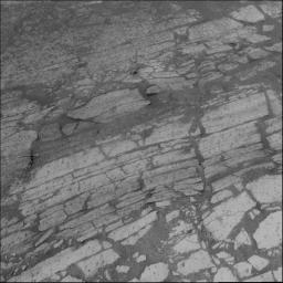
This image shows the area inside "Endurance Crater" that the Mars Exploration Rover Opportunity has been examining. The rover is investigating the distinct layers of rock that make up this region. Each layer is defined by subtle color and texture variations and represents a separate chapter in Mars' history. The deeper the layer, the further back in time the rocks were formed. Scientists are "reading" this history book by systematically studying each layer with the rover's scientific instruments. So far, data from the rover indicate that the top layers are sulfate-rich, like the rocks observed in "Eagle Crater." This implies that water processes were involved in forming the materials that make up these rocks.

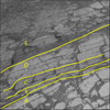
In figure 1, the layer labeled "A" in this picture contains broken-up rocks that most closely resemble those of "Eagle Crater." Layers "B,C and D" appear less broken up and more finely laminated. Layer "E," on the other hand, looks more like "A." At present, the rover is examining layer "D."

So far, data from the rover indicates that the first four layers consist of sulfate-rich, jarosite-containing rocks like those observed in Eagle Crater. This implies that water processes were involved in forming the materials that make up these rocks, though the materials themselves may have been laid down by wind.

This image was taken by Opportunity's navigation camera on sol 134 (June 9, 2004).

Image Credit:
NASA/JPL/Cornell

Image Addition Date:
2004-06-25