This view of the "Columbia Hills" in Gusev Crater was made by draping an image from the Mars Orbiter Camera on NASA's Mars Global Surveyor orbiter (image E0300012 from that camera) over a digital elevation model that was derived from two Mars Orbiter Camera images (E0300012 and R0200357).
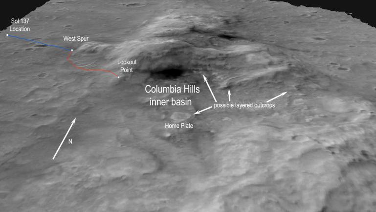
This unique view is helpful to the rover team members as they plan the journey of NASA's Mars Exploration Rover Spirit to the base of the Columbia Hills and beyond. Spirit successfully completed a three-month primary mission, and so far remains healthy in an extended mission of bonus exploration. As of sol 135 (on May 21, 2004), Spirit sits approximately 680 meters (0.4 miles) away from its first target at the western base of the hills, a spot informally called "West Spur." The team estimates that Spirit will reach West Spur by sol 146 (June 1, 2004). Spirit will most likely remain there for about a week to study the outcrops and rocks associated with this location.
When done there, Spirit will head approximately 620 meters (0.38 miles) to a higher-elevation location informally called "Lookout Point." Spirit might reach Lookout Point by around sol 165 (June 20, 2004). On the way, the rover will pass by and study ripple-shaped wind deposits that may reveal more information about wind processes on Mars.
Lookout Point will provide a great vantage point for scientists to remotely study the inner basin area of the Columbia Hills. This basin contains a broad range of interesting geological targets including the informally named "Home Plate" and other possible layered outcrops. These features suggest that the hills contain rock layers. Spirit might investigate the layers to determine whether they are water-deposited sedimentary rock.
Once at Lookout Point, Spirit will acquire 360-degree panoramic images of the entire area to help define the rover's next steps. Assuming the rover stays healthy, Spirit will eventually drive down into the basin to get an up-close look at interesting features there.
 Planetary Data System


