PDS logoPlanetary Data System
PDS Information
Find a Node - Use these links to navigate to any of the 8 publicly accessible PDS Nodes.

This bar indicates that you are within the PDS enterprise which includes 6 science discipline nodes and 2 support nodes which are overseen by the Project Management Office at NASA's Goddard Space Flight Center (GSFC). Each node is led by an expert in the subject discipline, supported by an advisory group of other practitioners of that discipline, and subject to selection and approval under a regular NASA Research Announcement.
Click here to return to the Photojournal Home Page Click here to view a list of Photojournal Image Galleries Photojournal_inner_header
Latest Images  |  Spacecraft & Technology  |  Animations  |  Space Images App  |  Feedback  |  Photojournal Search  

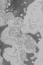
PIA05694: Carbon Dioxide Landforms
 Target Name:  Mars
 Is a satellite of:  Sol (our sun)
 Mission:  Mars Global Surveyor (MGS)
 Spacecraft:  Mars Global Surveyor Orbiter
 Instrument:  Mars Orbiter Camera (MOC)
 Product Size:  836 x 1254 pixels (w x h)
 Produced By:  Malin Space Science Systems
 Producer ID:  MOC2-670
 Full-Res TIFF:  PIA05694.tif (1.05 MB)
 Full-Res JPEG:  PIA05694.jpg (173.9 kB)

Click on the image above to download a moderately sized image in JPEG format (possibly reduced in size from original)

Original Caption Released with Image:

19 March 2004
The martian south polar residual ice cap is mostly made of frozen carbon dioxide. There is no place on Earth that a person can go to see the landforms that would be produced by erosion and sublimation of hundreds or thousands of cubic kilometers of carbon dioxide. Thus, the south polar cap of Mars is as alien as alien can get. This image, acquired in February 2004 by the Mars Global Surveyor (MGS) Mars Orbiter Camera (MOC), shows how the cap appears in summer as carbon dioxide is subliming away, creating a wild pattern of pits, mesas, and buttes. Darker surfaces may be areas where the ice contains impurities, such as dust, or where the surface has been roughened by the removal of ice. This image is located near 86.3°S, 0.8°W. This picture covers an area about 3 km (1.9 mi) across. Sunlight illuminates the scene from the top/upper left.

Image Credit:
NASA/JPL/Malin Space Science Systems

Image Addition Date:
2004-03-19