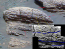
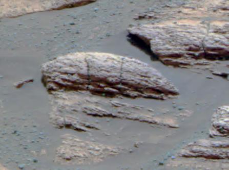
This image taken by the Mars Exploration Rover Opportunity's panoramic camera shows the rock nicknamed "Last Chance," which lies within the outcrop near the rover's landing site at Meridiani Planum, Mars. The image provides evidence for a geologic feature known as ripple cross-stratification. At the base of the rock, layers can be seen dipping downward to the right. The bedding that contains these dipping layers is only one to two centimeters (0.4 to 0.8 inches) thick. In the upper right corner of the rock, layers also dip to the right, but exhibit a weak "concave-up" geometry. These two features -- the thin, cross-stratified bedding combined with the possible concave geometry -- suggest small ripples with sinuous crest lines. Although wind can produce ripples, they rarely have sinuous crest lines and never form steep, dipping layers at this small scale. The most probable explanation for these ripples is that they were formed in the presence of moving water.
Crossbedding Evidence for Underwater Origin
Interpretations of cross-lamination patterns presented as clues to this martian rock's origin under flowing water are marked on images taken by the panoramic camera and microscopic imager on NASA's Opportunity.
 |  |
| Figure 1 | Figure 2 |
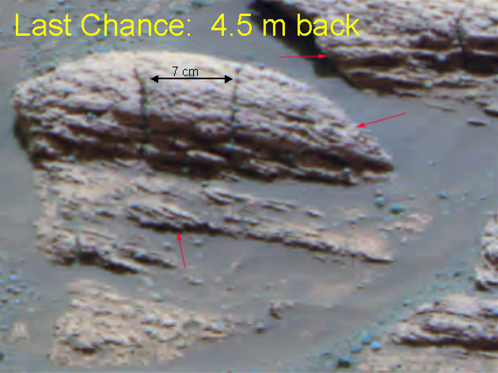
The red arrows (Figure 1) point to features suggesting cross-lamination within the rock called "Last Chance" taken at a distance of 4.5 meters (15 feet) during Opportunity's 17th sol (February 10, 2004). The inferred sets of fine layers at angles to each other (cross-laminae) are up to 1.4 centimeters (half an inch) thick. For scale, the distance between two vertical cracks in the rock is about 7 centimeters (2.8 inches). The feature indicated by the middle red arrow suggests a pattern called trough cross-lamination, likely produced when flowing water shaped sinuous ripples in underwater sediment and pushed the ripples to migrate in one direction. The direction of the ancient flow would have been either toward or away from the line of sight from this perspective. The lower and upper red arrows point to cross-lamina sets that are consistent with underwater ripples in the sediment having moved in water that was flowing left to right from this perspective.
The yellow arrows (Figure 2) indicate places in the panoramic camera view that correlate with places in the microscope's view of the same rock.
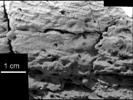
Figure 3The microscopic view (Figure 3) is a mosaic of some of the 152 microscopic imager frames of "Last Chance" that Opportunity took on sols 39 and 40 (March 3 and 4, 2004).
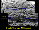
Figure 4Figure 4 shows cross-lamination expressed by lines that trend downward from left to right, traced with black lines in the interpretive overlay. These cross-lamination lines are consistent with dipping planes that would have formed surfaces on the down-current side of migrating ripples. Interpretive blue lines indicate boundaries between possible sets of cross-laminae.
 Planetary Data System


