PDS logoPlanetary Data System
PDS Information
Find a Node - Use these links to navigate to any of the 8 publicly accessible PDS Nodes.

This bar indicates that you are within the PDS enterprise which includes 6 science discipline nodes and 2 support nodes which are overseen by the Project Management Office at NASA's Goddard Space Flight Center (GSFC). Each node is led by an expert in the subject discipline, supported by an advisory group of other practitioners of that discipline, and subject to selection and approval under a regular NASA Research Announcement.
Click here to return to the Photojournal Home Page Click here to view a list of Photojournal Image Galleries Photojournal_inner_header
Latest Images  |  Spacecraft & Technology  |  Animations  |  Space Images App  |  Feedback  |  Photojournal Search  

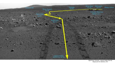
PIA05441: Covered Ground
 Target Name:  Mars
 Is a satellite of:  Sol (our sun)
 Mission:  Mars Exploration Rover (MER)
 Spacecraft:  Spirit
 Instrument:  Panoramic Camera
 Product Size:  1871 x 1022 pixels (w x h)
 Produced By:  JPL
 Full-Res TIFF:  PIA05441.tif (2.336 MB)
 Full-Res JPEG:  PIA05441.jpg (422.8 kB)

Click on the image above to download a moderately sized image in JPEG format (possibly reduced in size from original)

Original Caption Released with Image:

This image is a traverse map, illustrating Spirit's path over the last 45 sols. When the rover reached the point called "Laguna Hollow," it had driven 131 meters (430 feet) from Columbia Memorial Station. The rover heading is 45 degrees to the northeast. On the horizon behind the lander looms the landmark informally named "Grissom Hill." Over the relatively flat traverse, Spirit has made observations of rocks such as "Adirondack" and utilized the tools on its arm to investigate soil in several locations. Spirit stayed at "Laguna Hollow" for 3 sols, dug a trench and observed the floor and wall of it with three of the instruments on its arm: the Moessbauer spectrometer, the alpha particle X-ray spectrometer and the microscopic imager. Spirit is about halfway to the edge of the crater dubbed "Bonneville."

Image Credit:
NASA/JPL/OSU/Cornell

Image Addition Date:
2004-02-24