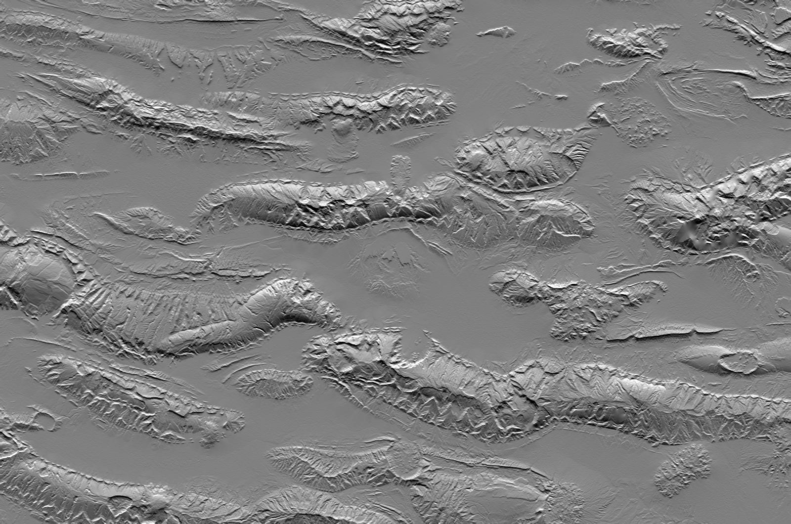
The Zagros Mountains in Iran offer a visually stunning topographic display of geologic structure in layered sedimentary rocks. This scene is nearly 100 kilometers (62 miles) wide but is only a small part of similar terrain that covers much of southern Iran. This area is actively undergoing crustal shortening, as global tectonics moves Arabia toward Asia. Consequently, layers of sedimentary rock are folding much like a carpet will fold if pushed. The convex upward folds create structures called anticlines, which are prominently seen here. The convex downward folds (between the anticlines) create structures called synclines, which are mostly buried and hidden by sediments eroding off the anticlines. Layers having differing erosional resistance create distinctive patterns, often sawtooth triangular facets, that encircle the anticlines. Local relief between the higher mountain ridges and their intervening valleys is about 1200 meters (about 4000 feet).
Salt extrusions and salt "glaciers" are another set of geologic features readily evident in the topography. Salt deposits, likely created by the evaporation of an ancient inland sea, were buried by the sediments that now make up the layers of the anticlines and synclines. But salt is less dense than most other rocks, so it tends to migrate upward through Earth's crust in vertical columns called "diapirs." The compressive folding process has probably facilitated the formation of these diapirs, and the diapirs, in turn, are probably enhancing some anticlines by "inflating" them with salt. Where the diapirs reach the surface, the salt extrudes, much like lava from a volcano, and the salt flows. Two prominent salt flows are evident in the same valley, leaking from neighboring anticlines, just north of the scene center.
This shaded relief image was created directly from an SRTM elevation model by computing topographic slope in the north-south direction. Northern slopes appear bright and southern slopes appear dark.
Elevation data used in this image were acquired by the Shuttle Radar Topography Mission (SRTM) aboard the Space Shuttle Endeavour, launched on February 11, 2000. SRTM used the same radar instrument that comprised the Spaceborne Imaging Radar-C/X-Band Synthetic Aperture Radar (SIR-C/X-SAR) that flew twice on the Space Shuttle Endeavour in 1994. SRTM was designed to collect three-dimensional measurements of the Earth's surface. To collect the 3-D data, engineers added a 60-meter-long (200-foot) mast, installed additional C-band and X-band antennas, and improved tracking and navigation devices. The mission is a cooperative project between the National Aeronautics and Space Administration (NASA), the National Geospatial-Intelligence Agency (NGA) of the U.S. Department of Defense (DoD), and the German and Italian space agencies. It is managed by NASA's Jet Propulsion Laboratory, Pasadena, Calif., for NASA's Earth Science Enterprise, Washington, D.C.
Size: 98.1 kilometers (60.8 miles) by 148.1 kilometers (91.8 miles)
Location: 27.3 degrees North latitude, 54.5 degrees East longitude
Orientation: North toward the top
Image Data: Shaded SRTM elevation model
Date Acquired: February 2000
