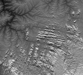
River drainage patterns provide clues to the rock types and erosional processes involved in landscape evolution. Here in the Gotel Mountains along the border between Nigeria and Cameroon two distinct and highly contrasting patterns are evident. The lowlands in the northern and northwestern parts of the scene exhibit "dendritic" patterns, while the highlands in the southern and southeastern parts of the scene show "rectangular" and other linear drainage patterns.
Dendritic drainage patterns appear almost random. Moving upstream, streams split into smaller and smaller channels, with finer and finer spacing, and they show little preference for map orientation other than to complete the pattern. In contrast, rectangular and other linear drainage patterns show a distinct preference for certain orientations in map view. In this scene, the two major preferred orientations are rotated slightly clockwise of north-south and east-west.
Linear drainage patterns usually match the cracking patterns that can occur in relatively hard rocks, including igneous rocks such as granite and basalt. Stream erosion typically follows such lines of weakness in these hard rocks. Meanwhile, the randomness of dendritic patterns indicates that no such cracks nor any other geologic structure controls the erosion where that pattern occurs.
Given the above, the topographic pattern in this scene appears to tell us the following about the geology of this location. The lowlands are composed of poorly consolidated (relatively soft) rocks or sediments that are at least 100 meters (330 feet) thick and are "massive" (uniform, with no prominent layering at the observed scale). The randomness of the dendritic patterns further indicates that stream erosion is the only significant dynamic process altering the lowland landscape. Forces such as volcanism and tectonics are not altering these landforms.
Meanwhile, the neighboring highlands are composed of crystalline rocks, such as granite, that are very hard (generally resistant to erosion) and probably very old. Sometime through their history these rocks cracked, perhaps when they cooled, perhaps under tectonic stress, or perhaps when pressure upon them was relieved when they were unearthed by erosion. Now at the surface, these cracks are zones of weakness as these hard rocks otherwise resist stream erosion.
But while the topographic data gives clues, it does not always provide definitive answers. Are the lowlands made up of soft sediments washed in from elsewhere or are they simply rocks "softened" by weathering (disintegration into sand) in place over time. If the latter, might they in fact have been granite also? The two patterns interfinger geographically, suggesting that the rugged highlands may be evolving into the dendritic lowlands. Weathering products (loose sands) tend to accumulate in place in low relief terrain because erosion there is slow to remove them. Also, granites are typically "massive" and cracking patterns vanish when the rocks disintegrate. The topographic data indeed provide thought provoking evidence, but definitive answers will require fieldwork or other additional evidence.
This image was created directly from an SRTM elevation model. A shade image was derived by computing topographic slope in the north-south direction. Northern slopes appear bright and southern slopes appear dark. The shade image was then merged with a height-as-brightness image, which helps clarify the continuity of the drainage networks.
Elevation data used in this image was acquired by the Shuttle Radar Topography Mission (SRTM) aboard the Space Shuttle Endeavour, launched on February 11, 2000. SRTM used the same radar instrument that comprised the Spaceborne Imaging Radar-C/X-Band Synthetic Aperture Radar (SIR-C/X-SAR) that flew twice on the Space Shuttle Endeavour in 1994. SRTM was designed to collect three-dimensional measurements of the Earth's surface. To collect the 3-D data, engineers added a 60-meter-long (200-foot) mast, installed additional C-band and X-band antennas, and improved tracking and navigation devices. The mission is a cooperative project between the National Aeronautics and Space Administration (NASA), the National Geospatial-Intelligence Agency (NGA) of the U.S. Department of Defense (DoD), and the German and Italian space agencies. It is managed by NASA's Jet Propulsion Laboratory, Pasadena, Calif., for NASA's Earth Science Enterprise, Washington, D.C.
Size: 144.8 kilometers (89.8 miles) by 131.5 kilometers (81.5 miles)
Location: 7 degrees North latitude, 10 degrees East longitude
Orientation: North toward the top
Image Data: SRTM elevation shaded plus height-as-brightness
Date Acquired: February 2000

 Planetary Data System


