The answers to this quiz appear in blue below each question.
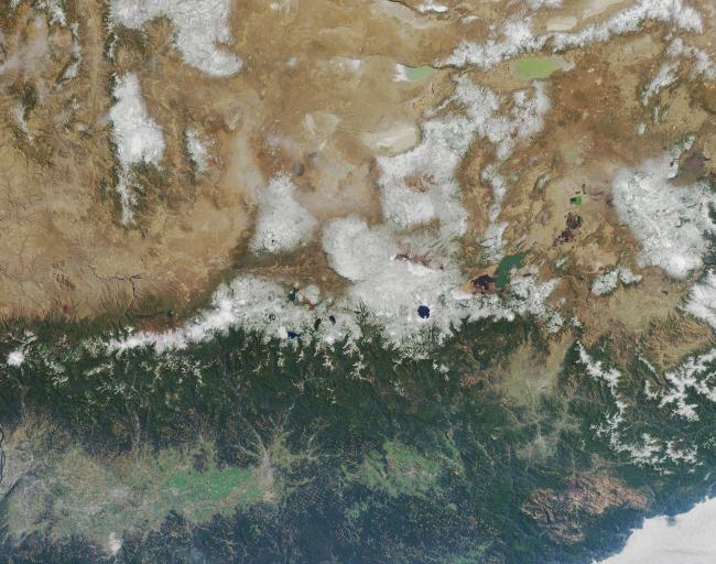
1. Situated below and to the right of image center there is a distinctive round lake with the small interior island off to the side of it. Three of the following four statements about the lake are true. Which one is false?
(A) The clarity of the water in that round lake is very good because the water does not come from surface catchments, but from rainfall or snow that fell directly into the lake and accumulated over time.
(B) The lake is the result of a volcanic eruption, which was recorded in the oral history and legends from the region.
(C) The small interior island was named for its resemblance to a particular style of head-wear.
(D) Soundings of the lake show that it is the deepest lake on the continent in which it is found.
Answer: (D) is FALSE.
Great Slave Lake in Canada's Northwest Territories is deeper. (A), (B) and (C) are true. Crater Lake is not stream-fed -- all the water in the lake is from direct rain and snowfall. When Mt. Mazama (the volcano that collapsed to produce the Crater Lake caldera) erupted about 9,000 years ago, that event was witnessed by Native Americans, and this observance is reflected in the role and significance that the Crater Lake region has in the oral tradition, religious tales and creation myths of the local Northwestern tribes. The interior island along the shores of Crater Lake was christened Wizard Island in August of 1885 by William Gladstone Steel, who named this volcanic cinder cone for the resemblance it bears to a wizard's cone-shaped hat.
2. Three of the following four statements concerning the landscape of the image area are true. Which one is false?
(A) Amid the snow-capped mountains near image center there is a collection of many lakes, some of which remain partially covered by ice throughout the year.
(B) In the lower right-hand corner is a large tan patch that is surrounded by the deep green forested areas. This large tan area indicates relatively bare soil and scarce vegetation resulting from the large forest fires that occurred there in 2002.
(C) Between 30 and 80 kilometers above and to the right of the distinctive round lake there are several irregularly shaped dark brown patches that contrast with the tan hue that dominates this part of the landscape. The dark brown areas are burn scars from fires that took place in 2003.
(D) The many small tan areas that appear like a patchwork pattern among the green forests in the lower half of the image indicate logging activities -- only about 10 percent of the forested ecoregion within the lower-right-hand portion of the image area is legally protected from logging.
Answer: Either (A) or (C) or (D) were accepted as FALSE.
(A) is false: Although almost all of the lakes within the image area are not frozen during summer, in Oregon's Three Sisters Wilderness area there are several very small lakes that contain icebergs even in late summer.
(B) is true: The large tan area in the lower right is a burn scar in the Klamath Mountains that started in southwestern Oregon and eventually burned over into California -- the Biscuit Fire had consumed more than 400,000 acres by late August 2002.
(C) is false: The dark brown areas situated between 30 and 80 kilometers to the RIGHT (southeast) of Crater Lake are related to irrigation. However, the dark brown areas situated between 30 and 80 kilometers to the LEFT (northeast) of Crater Lake are indeed associated with burn scars resulting from the B& B complex fires that took place in 2003.
(D) is CONTESTABLE. Although the patchwork pattern that predominates is related to logging, the question does not adequately define the 'forested ecoregion', so it is difficult to determine whether more or less than about 10% of the forests along the coastal ranges of Northern California and Southern Oregon are protected.
3. Three of the following four statements related to energy sources within the image area are false. Which one is true?
(A) There is an active uranium mining site within the image area.
(B) Coal has been in continuous production since the 1950s at a coal mine situated in the lower-right-hand image area.
(C) The first hydroelectricity power-generating station within the image area was not established until the first decade of the 20th century.
(D) Situated within the lower-right-hand portion of the image area is a well over 500 meters deep, which was drilled for the purpose of harnessing geothermal energy.
Answer: D is TRUE.
The geothermal project at Crump Geyser, Oregon, is situated in the Warner Valley, Lake County, 30 miles east of Lakeview, Oregon, and 175 miles north of Winnemucca, Nevada.
(A) is false: The Aurora uranium mine is located to the east of the image border in southeastern Oregon, approximately 10 miles northwest of McDermitt, Nevada, whilst the Fremont National Forest/White King Mine (near the town of Lakeview north of Goose Lake) is no longer active.
(B) is also false: In 1908, the city of Ashland, OR, installed its own 300-kilowatt hydroelectric plant in the hills above Ashland. However, in 1889, Oregon City established the Willamette Falls station, which was the first AC hydroelectric plant. Single phase power was transmitted 13 miles to Portland at 4,000 volts, stepped down to 50 volts for distribution.
(C) is also false: Although large amounts of coal were mined in Coos County, Oregon, and shipped to California between 1890 and 1910, no coal mines in that county have been in production since 1950. Neither California nor Oregon has any active coal mines.
4. Three of the following four statements about the ecology and geology of the region are true. Which one is false?
(A) In the upper-right-hand image corner there are several large, shallow, closed-basin alkaline lakes that support brine shrimp and other aquatic invertebrates, which in turn supply food for millions of migratory birds.
(B) Around the water bodies and rivers throughout this region are many known breeding locations for large birds of the genus Haliaeetus.
(C) Within the lower half of the image area is a lava-tube in which the longest uncollapsed segment measures more than three kilometers long.
(D) In the upper-left-hand part of the image there is a landscape that, due to ancient lava flow, remains almost entirely devoid of vegetation across an area of about 1,600 acres -- and that lava-flow landscape was used in the 1960s as an analogue for an extraterrestrial environment during scientific simulation studies.
Ape Cave lava tube in Washington State is the longest known lava tube (at about 3.9 kilometers) in the conterminous United States, but there aren't any known lava tubes longer than about 2.4km within the image area. (A), (B) and (D) are true: The Bald Eagle (Haliaeetus leucocephalus) is a widespread breeder within the region in all but desert habitats. US astronauts trained in 1964 amidst the 'moonscape' along the Cascade Lakes Highway near Lava Butte, in preparation for the Apollo missions to the moon. Although the Lava Butte region is located within the upper left quadrant of the image, it is positioned toward the lower right within this quadrant, thus placing it somewhat centrally within the image. Since D is somewhat contestable, respondents who noted this particular ambiguity in their answer were marked correct.
MISR was built and is managed by NASA's Jet Propulsion Laboratory,
Pasadena, CA, for NASA's Office of Earth Science, Washington, DC. The
Terra satellite is managed by NASA's Goddard Space Flight Center,
Greenbelt, MD. JPL is a division of the California Institute of
Technology.