Desert dust particles tend to be larger in size than aerosols that originate from the processes of combustion. How precisely do the size of the aerosol particles comprising the dust that obscured the Red Sea on July 26, 2005, contrast with the size of the haze particles that obscured the United States eastern seaboard on the same day? NASA's Multi-angle Imaging SpectroRadiometer (MISR), which views Earth at nine different angles in four wavelengths, provides information about the amount, size, and shape of airborne particles. Here, MISR aerosol amount and size is presented for these two events. These MISR results distinguish desert dust, the most common non-spherical aerosol type, from pollution and forest fire particles. Determining aerosol characteristics is a key to understanding how aerosol particles influence the size, abundance, and rate of production of cloud droplets, and to a better understanding of how aerosols influence clouds and climate.
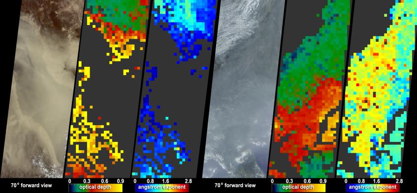
The left panel of each of these two image sets (Red Sea, left; U.S. coastline, right) is a natural-color view from MISR's 70-degree forward viewing camera. The color-coded maps in the central panels show aerosol optical depth; the right panels provide a measure of aerosol size, expressed as the "Angstrom exponent." For the optical depth maps, yellow pixels indicate the most optically-thick aerosols, whereas the red, green and blue pixels represent progressively decreasing aerosol amounts. For this dramatic dust storm over the Red Sea, the aerosol is quite thick, and in some places, the dust over water is too optically thick for MISR to retrieve the aerosol amount. For the eastern seaboard haze, the thickest aerosols have accumulated over the Atlantic Ocean off the coasts of South Carolina and Georgia. Cases where no successful retrieval occurred, either due to extremely high aerosol optical thickness or to clouds, appear as dark gray pixels.
For the Angstrom exponent maps, the blue and green pixels (smaller values) correspond with more large particles, whilst the yellow and red pixels, representing higher Angstrom exponents, correspond with more small particles. Angstrom exponent is related to the way the aerosol optical depth (AOD) changes with wavelength -- a more steeply decreasing AOD with wavelength indicates smaller particles. The greater the magnitude of the Angstrom exponent, the greater the contribution of smaller particles to the overall particle distribution. For optically thick desert dust storms, as in this case, the Angstrom exponent is expected to be relatively low -- likely below 1. For the eastern seaboard haze, the Angstrom exponent is significantly higher, indicating the relative abundance of small pollution particles, especially over the Atlantic where the aerosol optical depth is also very high.
With a nearly simultaneous data acquisition time, the MODIS instrument also collected data for these events, and image features for both the dust storm and the haze are available.
The Multi-angle Imaging SpectroRadiometer observes the daylit Earth continuously, viewing the entire globe between 82° north and 82° south latitude every nine days. This image covers an area of about 1,265 kilometers by 400 kilometers. These data products were generated from a portion of the imagery acquired during Terra orbits 29809 and 29814 and utilize data from blocks 60 to 67 and 71 to 78 within World Reference System-2 paths 17 and 170, respectively.
MISR was built and is managed by NASA's Jet Propulsion Laboratory, Pasadena, CA, for NASA's Science Mission Directorate, Washington, DC. The Terra satellite is managed by NASA's Goddard Space Flight Center, Greenbelt, MD. JPL is managed for NASA by the California Institute of Technology.