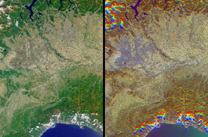
The lowlands of Lombardy and Piedmont in northwest Italy are some of the most highly developed irrigation areas in the world. Irrigated lands cover at least 160,000 acres in this part of Italy, where rice is the most important crop. These views of the region were acquired on May 8, 2005, by NASA's Multi-angle Imaging SpectroRadiometer (MISR). The multiangular nature of MISR allows wet surfaces and lands inundated with water to be differentiated from other surface types, and is also used here to identify cities.
The left-hand image is a natural color view acquired by MISR's downward-looking (nadir) camera, and the right-hand image is a multi-angular composite. The composite was created using data from three of the MISR cameras, with red band data from MISR's 60º backward-viewing, nadir and 60º forward-viewing cameras, displayed as red, green and blue, respectively. Here, color changes indicate surface texture, which is influenced by terrain, vegetation structure, soil type and surface wetness. Wet surfaces or areas with standing water appear in blue or purple-blue hues, because sun glitter (an ensemble of specular reflection points) causes smooth, wet surfaces to look brighter to a camera that is pointing toward the Sun. The purple-blue areas indicate the extensive irrigation network that exists throughout the plains and meadows of Lombardy and Piedmont.
Cities with tall buildings appear to be "rough" surfaces because of their vertical structures and appear in red-orange hues. Using this display technique, the cities of Milan and Vercelli can be readily identified. The area of orange pixels situated roughly at the center of the purple inundation area indicates the location of Vercelli, and Milan can be located by the large orange area that appears to the northeast of Vercelli. To a lesser extent, the cities of Novara, Pavia, Galliate, Mortara and Vigevano are also identifiable by their orange hues.
MISR can detect these textural differences because of the way surfaces reflect light. Smooth, mirror-like surfaces (such as water) tend to reflect more sunlight back toward the observer when the Sun is situated in front of the viewer. A rough area such as city, in which the surface structure casts large shadows, tends to reflect more sunlight from its illuminated surfaces when the Sun is behind the viewer. This is why the urban areas appear brighter to the MISR cameras that point away from the Sun. Clouds appear over the hills to the west of the Lago Maggiore and along the coast of the Golfo di Genova. The clouds appear in a different spot for each view angle, creating a rainbow-like appearance. Similarly, the mountainous areas exhibit a "wavy" appearance, since they also appear in a different spot for each view angle due to their height above the reference ellipsoid.
The Multi-angle Imaging SpectroRadiometer observes the daylit Earth continuously, viewing the entire globe between 82° north and 82° south latitude every nine days. This image covers an area of about 131 kilometers by 191 kilometers. These data products were generated from a portion of the imagery acquired during Terra orbit 28660 and utilize data from block 54 within World Reference System-2 path 193.
MISR was built and is managed by NASA's Jet Propulsion Laboratory, Pasadena, CA, for NASA's Science Mission Directorate, Washington, DC. The Terra satellite is managed by NASA's Goddard Space Flight Center, Greenbelt, MD. JPL is managed for NASA by the California Institute of Technology.
 Planetary Data System


