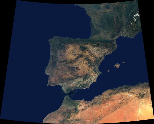
Data from a portion of the imagery acquired by the Multi-angle Imaging SpectroRadiometer's vertical-viewing (nadir) camera during 2000-2002 were combined to create this cloud-free natural-color mosaic of southwestern Europe and northwestern Morocco and Algeria. The image extends from 48°N, 16°W in the northwest to 32°N, 8°E in the southeast. It is displayed in Albers conic equal-area projection (a projection which is frequently used for equal-area maps of regions that are predominantly east-west in extent).
From the northeast, the image traverses a portion of the Swiss Alps (partially snow-covered) and a small part of Italy's Po Valley. The northern portion of the image also includes the western coast of France and much of southern and southwestern France's undulating terrain, which continues until reaching the hills of the Pyrenees. The Pyrenees act as the natural frontier to the Iberian Peninsula -- a landmass comprised of Spain and Portugal. The Peninsular landscapes are extremely varied, with some almost desert-like, others green and fertile. About half of Spain is situated atop a high plain, known as the Central Plateau, and many mountain ranges, rivers, geological basement rock and vegetation types are found across this great plateau. The largest alluvial plain is Andalusia in the south, where the valley of the Guadalquivir River is shut in by mountain ranges on every side except the southwest, where the valley descends to the Atlantic. The islands of Mallorca, Menorca and Ibiza are Spanish territories in the western Mediterranean. At the Strait of Gibralter, Spain and Morocco very nearly kiss, and Morocco appears relatively verdant along its northern coastal corner. The rugged Atlas Mountain ranges traverse northern Algeria and Morocco.
The Multi-angle Imaging SpectroRadiometer observes the daylit Earth continuously from pole to pole, and every 9 days views the entire globe between 82 degrees north and 82 degrees south latitude. This data product was generated from a portion of the imagery acquired during 2000-2002.MISR was built and is managed by NASA's Jet Propulsion Laboratory, Pasadena, CA, for NASA's Office of Earth Science, Washington, DC. The Terra satellite is managed by NASA's Goddard Space Flight Center, Greenbelt, MD. JPL is a division of the California Institute of Technology.