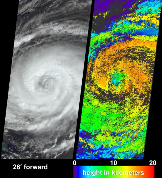
After causing widespread destruction on Puerto Rico, Haiti and the Dominican Republic, Hurricane Jeanne was weakened to Tropical Storm status for several days before it regained strength over the Bahamas as a Category 2 hurricane. When Jeanne made landfall in U.S. territory on September 26 it was the fourth major hurricane of the 2004 Atlantic hurricane season to strike Florida. These visualizations of Hurricane Jeanne on September 24 were captured by NASA's Multi-angle Imaging SpectroRadiometer (MISR). The still panels include a natural color view from MISR's 26-degree forward-viewing camera (left) and a two dimensional map of cloud-top heights (right). In addition, a "multi-angle fly-over" is provided as an animation using views from all nine MISR cameras.
The nine camera views which make up the animation have been processed togive an approximate perspective view. The animation makes visible therelative heights of clouds within the scene. Some of the real cloudmotion over the seven minutes during which all nine MISR camerasobserved the scene are also indicated by the animation. The cloud heightmap was produced by automated computer recognition of the distinctivespatial features between images acquired at different view angles.Two-dimensional maps of cloud height such as these offer an opportunityto compare simulated cloud fields against actual hurricane observations.Results indicate that clouds within Jeanne had attained altitudes ofmore than 16 kilometers above sea level. The height field pictured hereis uncorrected for the effects of cloud motion. Wind-corrected heightshave higher accuracy but sparser spatial coverage.
The Multi-angle Imaging SpectroRadiometer observes the daylit Earth continuously and every 9 days views the entire globe between 82° north and 82° south latitude. These data products were generated from a portion of the imagery acquired during Terra orbit 25372. The still image panels cover an area of about 400 kilometers x 884 kilometers, and utilize data from within blocks 68 to 71 and within World Reference System-2 path 10.
MISR was built and is managed by NASA's Jet Propulsion Laboratory, Pasadena, CA, for NASA's Office of Earth Science, Washington, DC. The Terra satellite is managed by NASA's Goddard Space Flight Center, Greenbelt, MD. JPL is a division of the California Institute of Technolog