The answers to this quiz appear in blue below each question.
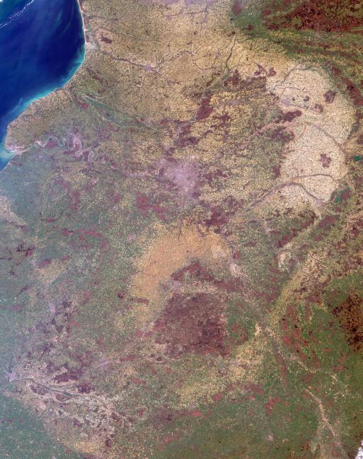
1. The soils in the prominent pale tan area in the upper right are derived
from marine fossil sediments that accumulated there over two million years
ago. Partly because of its well-drained, chalky soils, this region is
renowned for a particular agricultural product. What is that product?
Answer: "Grapes", "wine", and "champagne" were all accepted as correct
answers.
The pale tan country is within a production area known as "La Champagne",
best known for the production of the sparkling white wine that bears the
region's name. The deep chalky subsoil stores the sun’s heat and reflects
warmth into the vine roots, in addition to assuring good drainage, preserving
humidity in the soil and supplying mineral elements to the vines. The area of
Champagne production was established by law in 1927 and is protected by
a committee that administers vine growing and wine making in the region and
protects the name of Champagne.
2. The large river apparent just above image center traverses agricultural,
urban, pastoral and forested lands before emerging at the coast in the
upper left. Below are three true statements about water quality in the
river now, as compared with 30 years ago, and one false statement. Which
one is the false statement?
(A) The concentration of dissolved oxygen in the waters of the river is
now lower.
(B) The concentration of nitrates in the waters of the river is now
higher.
(C) The concentration of phosphate in the waters of the river is now
lower.
(D) The number of fish and the diversity of species found in the waters of
the river is now higher.
Answer: A
Forty years ago the Seine River was nearly dead: Out of the 33 fish species
that have been identified as belonging to the local ecosystem, only 3 of them
could occasionally be spotted at Paris during the early 1960's. Today,
twenty-six are commonly found within the Seine-Normandy river basin. After
becoming seriously depleted in the 1960s, the dissolved oxygen content has
also increased, with oxygen at one measuring station in the lower Seine
increasing by 0.9 percent/year over the last 25 years. The levels of phosphate
entering the Seine estuary, although still considered to be too high, have
decreased from 60 t/day to 39 t/day between 1974 and 1999. However, the
concentration of nitrate pollution from fertilizers continues to increase. For more
information, see the World Water Assessment Program for the Seine-Normandy Basin.
3. The aforementioned river flows through a city, indicated by the pale
purple-gray area above image center. Many of the city's notable
architectural monuments are located along the river. Are the majority of
these monuments situated upstream or downstream of the island at the city's
center?
Answer:
Paris geography is centered on the Seine River. The ports and the center of
commercial river traffic are upstream of the city center, Ile de la Cite. Downstream
is the heart of aristocratic Paris, and includes the famous monuments such as
Notre Dame, the Eiffel Tower and the Louvre.
4. There are two wetland areas within the image that have been
internationally recognized for their significance. Two of these statements
are true for one wetland and the other two are true for the other wetland.
In which combination (AB-CD, AC-BD or BC-AD) should the statements be
paired?
(A) thousands of small man-made and semi-natural lakes are found here
(B) the sea eagle regularly spends its winters here
(C) there are 50 different types of dragonfly found here
(D) this lowland complex includes three major vegetation zones
Answer: AC- BD
There are two sites designated as Wetlands of International Importance
within the image area. One of these sites is the Etangs de la Champagne
Humide Regional Natural Park, located in the Champagne-Ardenne district.
This lowland complex of rivers, reservoir lakes and forests, ponds, canals,
gravel pits, reedbeds, wet meadows and alluvial forests encompasses three
major vegetation zones and is an important site for wintering and passage of
migratory waterbirds, including geese, ducks, cranes and herons. It is also the
only regular French wintering site for the globally threatened sea eagle. The
other site is the La Brenne Regional Natural Park, situated in the plateau
region of the Centre district. La Brenne is one of the most important areas of
etangs (lakes) in France, including about 1,500 semi-natural lakes and ponds,
many of which were formed by levee construction in the Middle Ages. The
landscape includes heath, forests, wet meadows, dry grasslands, cultivated
land and numerous fish farms. The diverse fauna includes 50 dragonfly species,
150 migratory birds, 10 reptiles and 14 amphibians.
5. Two clusters of very dark brown pixels surrounded by green, are apparent
in the top right-hand corner and at the right-hand edge toward the bottom.
Which of the following best describes both of these areas in terms of
surface characteristics?
(A) low-lying pasture and cropland
(B) high-country forest
(C) low-lying forest
(D) high-country pasture and cropland
Answer: B
The best description for the clusters of very dark brown pixels surrounded
by green is high-country forest. In the top right-hand corner the dark areas
correspond with forests within the hilly Ardennes region. Although the hills
of the Ardennes rarely rise above 500 meters, this terrain is high-country
compared with the surrounding districts. The dark area at the right-hand
edge toward the bottom of the image is a "mountainous" granite outcrop in
Burgundy called the Monts du Morvan, whose name comes from the Gaulish
for "black mountain". The highest summit within the Monts du Morvan is
slightly above 900 meters.
MISR was built and is managed by NASA's Jet Propulsion Laboratory,
Pasadena, CA, for NASA's Office of Earth Science, Washington, DC. The
Terra satellite is managed by NASA's Goddard Space Flight Center,
Greenbelt, MD. JPL is a division of the California Institute of
Technology.
 Planetary Data System


