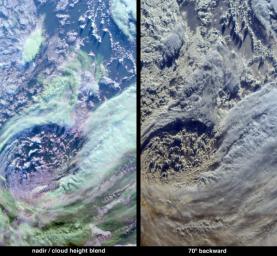
The complex structure and beauty of polar clouds are highlighted by these images acquired by the Multi-angle Imaging SpectroRadiometer (MISR) on April 23, 2003. These clouds occur at multiple altitudes and exhibit a noticeable cyclonic circulation over the Southern Indian Ocean, to the north of Enderbyland, East Antarctica.
The image at left was created by overlying a natural-color view from MISR's downward-pointing (nadir) camera with a color-coded stereo height field. MISR retrieves heights by a pattern recognition algorithm that utilizes multiple view angles to derive cloud height and motion. The opacity of the height field was then reduced until the field appears as a translucent wash over the natural-color image. The resulting purple, cyan and green hues of this aesthetic display indicate low, medium or high altitudes, respectively, with heights ranging from less than 2 kilometers (purple) to about 8 kilometers (green). In the lower right corner, the edge of the Antarctic coastline and some sea ice can be seen through some thin, high cirrus clouds.
The right-hand panel is a natural-color image from MISR's 70-degree backward viewing camera. This camera looks backwards along the path of Terra's flight, and in the southern hemisphere the Sun is in front of this camera. This perspective causes the cloud-tops to be brightly outlined by the sun behind them, and enhances the shadows cast by clouds with significant vertical structure. An oblique observation angle also enhances the reflection of light by atmospheric particles, and accentuates the appearance of polar clouds. The dark ocean and sea ice that were apparent through the cirrus clouds at the bottom right corner of the nadir image are overwhelmed by the brightness of these clouds at the oblique view.
The Multi-angle Imaging SpectroRadiometer observes the daylit Earth continuously from pole to pole, and every 9 days views the entire globe between 82 degrees north and 82 degrees south latitude. These data products were generated from a portion of the imagery acquired during Terra orbit 17794. The panels cover an area of 335 kilometers x 605 kilometers, and utilize data from blocks 142 to 145 within World Reference System-2 path 155.
MISR was built and is managed by NASA's Jet Propulsion Laboratory, Pasadena, CA, for NASA's Office of Earth Science, Washington, DC. The Terra satellite is managed by NASA's Goddard Space Flight Center, Greenbelt, MD. JPL is a division of the California Institute of Technology.

 Planetary Data System


