The answers to this quiz appear in blue below each question.
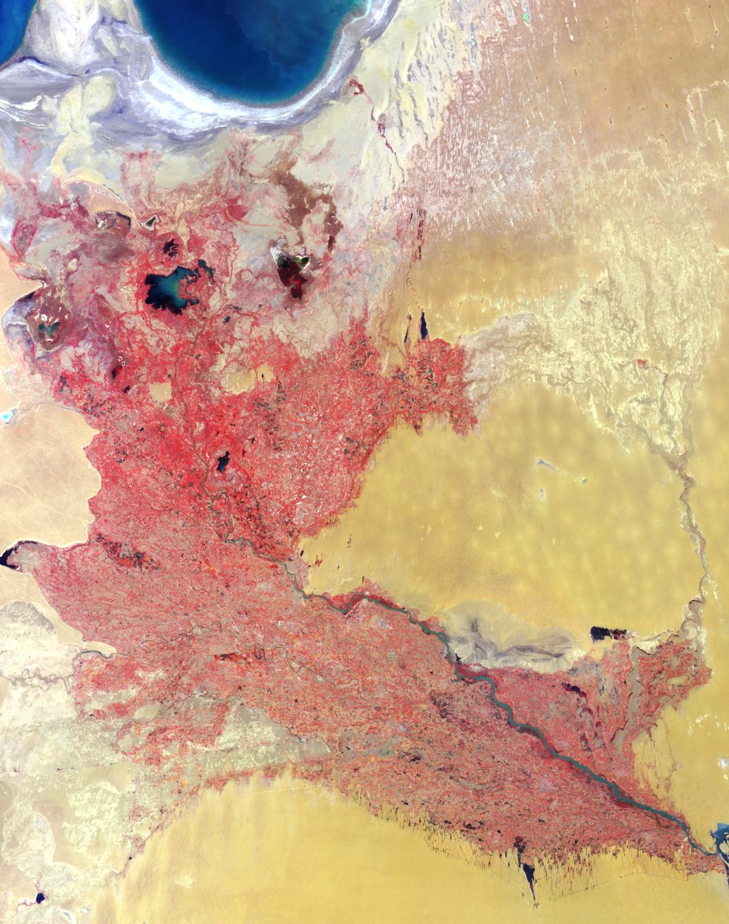
1. Three of the following four statements about the two countries
contained with image area are true. Which one is false?
(A) They are among the world's top cotton producers.
(B) One celebrates Independence Day in March; the other in April.
(C) They are both landlocked.
(D) Soil in both countries has been subjected to increasing salinization.
Answer: B is false
The Amu Darya river forms a wide delta in the western deserts of
Uzbekistan and northeastern Turkmenistan, and the river waters
are utilized intensively to irrigate cotton and other crops. During
the Soviet era, large irrigation systems were developed and the
region became specialized in cotton growing. Independence from
the Soviet Union occurred in 1991 and is celebrated by Uzbekistan
on September 1st and by Turkmenistan on October 27th. Both of
these landlocked countries are losing arable land to soil salinization
as a result of rising groundwater levels that accompany crop irrigation.
2. Three of the following four statements about the large water bodies
in the upper left-hand corner of the image are false. Which one is true?
(A) Increasing agricultural demands caused a 75% drop in water
volume during the last few decades.
(B) Water volume increased by about 15% in the last decade due to
a change in the availability of glacial meltwater.
(C) Increased commercial fishing in these waters over the past few
decades has led to economic growth in the region.
(D) These freshwater bodies provided the setting for an international
athletic competition held in the mid 1990's.
Answer: A is true
As a consequence of the diversion of vast quantities of freshwater from
the Amu Darya and Syr Darya rivers, water volume in the Aral Sea has
dropped by more than 80% since 1960. Increases in water input near
the river's source (from precipitation or glacial meltwater) do not compensate
for the water lost from this shrinking inland sea. Commercial fishing in the
region has ceased.
3. Three of the following four statements about the major river system
that diagonally traverses the image area are true. Which one is false?
(A) Parts of the river demarcate international political boundaries.
(B) The total number of fish species supported by the river system has
decreased since the middle of the 20th century.
(C) The direction of water flow is from the upper left portion of the image
toward the lower right.
(D) The river changed its course during the 17th century, prompting a
city within the image area to relocate and re-build closer to the new
riverbed.
Answer: C is false
A portion of the border between western Uzbekistan and northeastern
Turkmenistan follows the course of the Amu Darya river. Within the river
system, about 50 fish species could be found during the 1960's; that
number has dropped to approximately 20. Within the area of this image,
the width of the main river is widest in the lower right-hand corner (closer
to its source in the mountains of Afghanistan) and is greatly reduced by
the time it reaches the edges of the dwindling Aral Sea. However, both
the Amu Darya and the Aral Sea have experienced dramatic changes in
response to past climate and probably also in response to historical
irrigation practices. The new and old site of the city of Urgench is one
indication of the river's dynamic nature.
MISR was built and is managed by NASA's Jet Propulsion Laboratory,
Pasadena, CA, for NASA's Office of Earth Science, Washington, DC. The
Terra satellite is managed by NASA's Goddard Space Flight Center,
Greenbelt, MD. JPL is a division of the California Institute of
Technology.
 Planetary Data System


