PDS logoPlanetary Data System
PDS Information
Find a Node - Use these links to navigate to any of the 8 publicly accessible PDS Nodes.

This bar indicates that you are within the PDS enterprise which includes 6 science discipline nodes and 2 support nodes which are overseen by the Project Management Office at NASA's Goddard Space Flight Center (GSFC). Each node is led by an expert in the subject discipline, supported by an advisory group of other practitioners of that discipline, and subject to selection and approval under a regular NASA Research Announcement.
Click here to return to the Photojournal Home Page Click here to view a list of Photojournal Image Galleries Photojournal_inner_header
Latest Images  |  Spacecraft & Technology  |  Animations  |  Space Images App  |  Feedback  |  Photojournal Search  

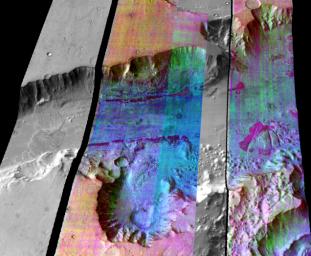
PIA04262: Ganges Chasma
 Target Name:  Mars
 Is a satellite of:  Sol (our sun)
 Mission:  2001 Mars Odyssey
 Spacecraft:  2001 Mars Odyssey
 Instrument:  THEMIS
 Product Size:  1463 x 1203 pixels (w x h)
 Produced By:  Arizona State University
 Full-Res TIFF:  PIA04262.tif (4.195 MB)
 Full-Res JPEG:  PIA04262.jpg (365.6 kB)

Click on the image above to download a moderately sized image in JPEG format (possibly reduced in size from original)

Original Caption Released with Image:

This false-color infrared image was taken by the camera system on the Mars Odyssey spacecraft over part of Ganges Chasma in Valles Marineris (approximately 13 degrees S, 318 degrees E). The infrared image has been draped over topography data obtained by Mars Global Surveyor. The color differences in this image show compositional variations in the rocks exposed in the wall and floor of Ganges (blue and purple) and in the dust and sand on the rim of the canyon (red and orange). The floor of Ganges is covered by rocks and sand composed of basaltic lava that are shown in blue. A layer that is rich in the mineral olivine can be seen as a band of purple in the walls on both sides of the canyon, and is exposed as an eroded layer surrounding a knob on the floor. Olivine is easily destroyed by liquid water, so its presence in these ancient rocks suggests that this region of Mars has been very dry for a very long time. The mosaic was constructed using infrared bands 5, 7, and 8, and covers an area approximately 150 kilometers (90 miles) on each side. This simulated view is toward the north.

NASA's Jet Propulsion Laboratory manages the 2001 Mars Odyssey mission for NASA's Office of Space Science, Washington, D.C. The thermal emission imaging system was provided by Arizona State University, Tempe. Lockheed Martin Astronautics, Denver, Colo., is the prime contractor for the project, and developed and built the orbiter. Mission operations are conducted jointly from Lockheed Martin and from JPL, a division of the California Institute of Technology in Pasadena.

Image Credit:
NASA/JPL/Arizona State University

Image Addition Date:
2003-03-13