Click on the image for the animationAbout the animation: This simulated view of the potential effects of storm surge flooding on Lake Pontchartrain and the New Orleans area was generated with data from the Shuttle Radar Topography Mission. Although it is protected by levees and sea walls against storm surges of 18 to 20 feet, much of the city is below sea level, and flooding due to storm surges caused by major hurricanes is a concern. The animation shows regions that, if unprotected, would be inundated with water. The animation depicts flooding in one-meter increments.
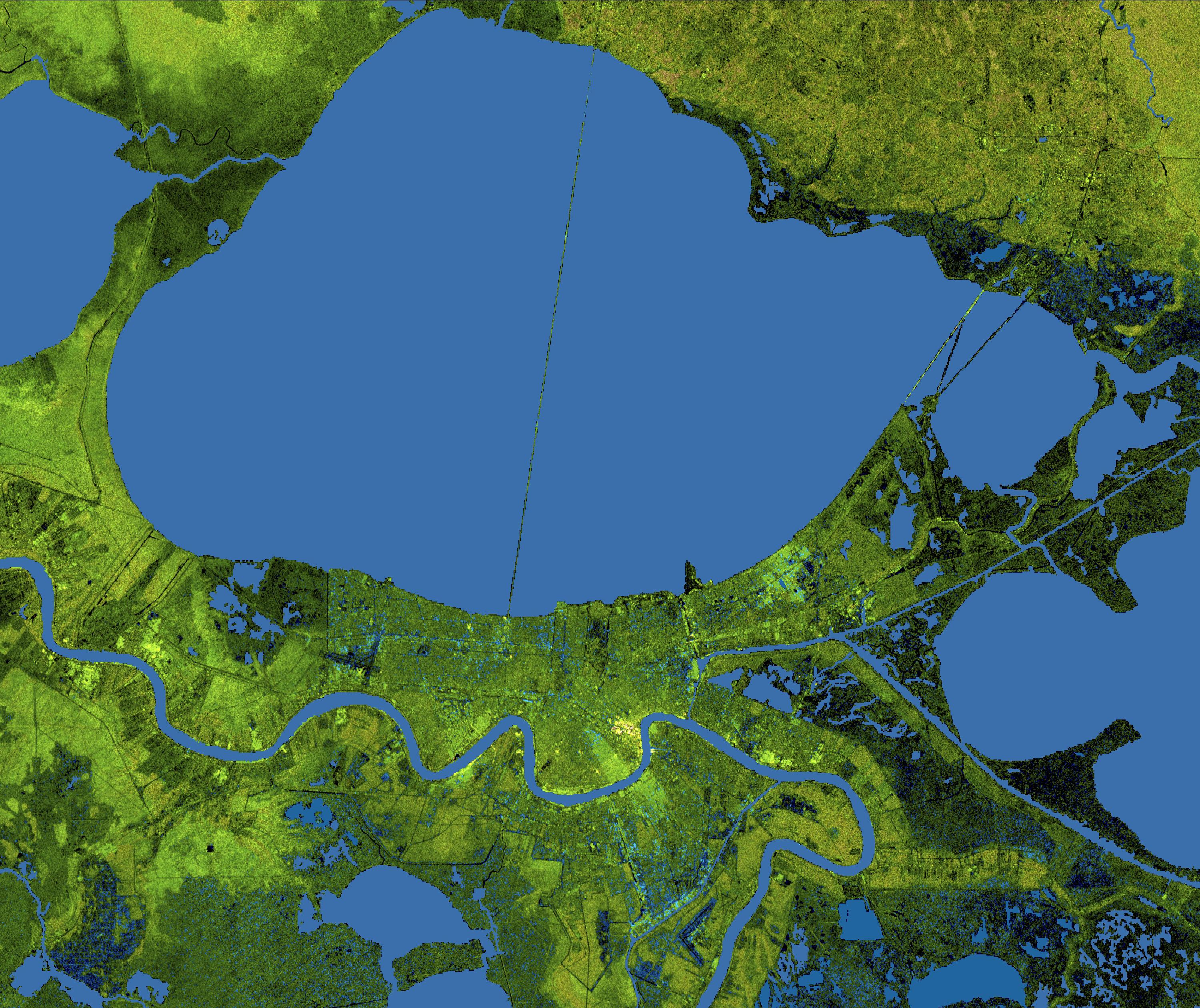
About the image: The city of New Orleans, situated on the southern shore of Lake Pontchartrain, is shown in this radar image from the Shuttle Radar Topography Mission (SRTM). In this image bright areas show regions of high radar reflectivity, such as from urban areas, and elevations have been coded in color using height data also from the SRTM mission. Dark green colors indicate low elevations, rising through yellow and tan, to white at the highest elevations.
New Orleans is near the center of this scene, between the lake and the Mississippi River. The line spanning the lake is the Lake Pontchartrain Causeway, the world's longest overwater highway bridge. Major portions of the city of New Orleans are actually below sea level, and although it is protected by levees and sea walls that are designed to protect against storm surges of 18 to 20 feet, flooding during storm surges associated with major hurricanes is a significant concern.
Data used in this image were acquired by the Shuttle Radar Topography Mission aboard the Space Shuttle Endeavour, launched on Feb. 11, 2000. SRTM used the same radar instrument that comprised the Spaceborne Imaging Radar-C/X-Band Synthetic Aperture Radar (SIR-C/X-SAR) that flew twice on the Space Shuttle Endeavour in 1994. SRTM was designed to collect 3-D measurements of the Earth's surface. To collect the 3-D data, engineers added a 60-meter (approximately 200-foot) mast, installed additional C-band and X-band antennas, and improved tracking and navigation devices. The mission is a cooperative project between NASA, the National Geospatial-Intelligence Agency (NGA) of the U.S. Department of Defense and the German and Italian space agencies. It is managed by NASA's Jet Propulsion Laboratory, Pasadena, Calif., for NASA's Science Mission Directorate, Washington, D.C.
Location: 30.2 degrees North latitude, 90.1 degrees East longitude
Orientation: North toward the top, Mercator projection
Size: 80.3 by 68.0 kilometers (49.9 by 42.3 miles)
Image Data: Radar image and colored Shuttle Radar Topography Mission elevation model
Date Acquired: February 2000
 Planetary Data System


