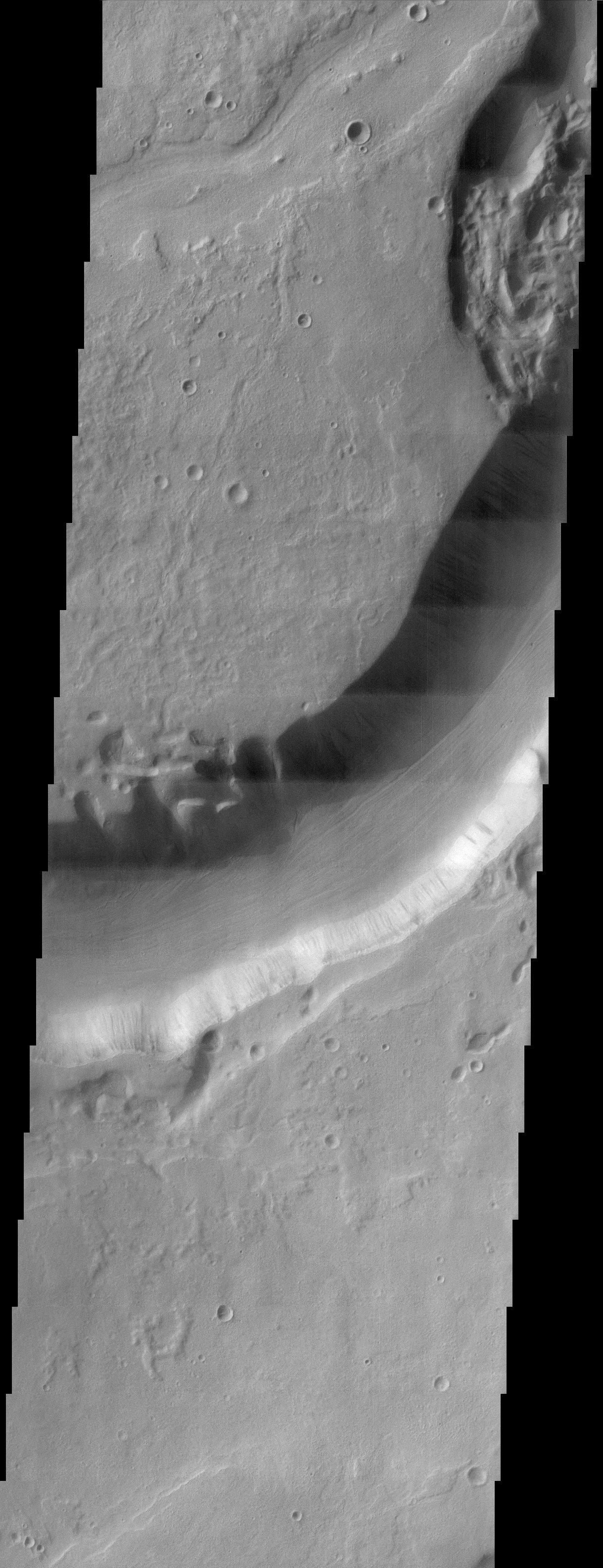
This THEMIS visible image shows Dao Vallis, a large outflow channel that starts on the southeast flank of a large volcano called Hadriaca Patera and runs for 1000 kilometers southwest into the Hellas impact basin. The channel is up to 20 kilometers wide near its source, but narrows downstream. As can be seen in the context image, the part of Dao Vallis imaged by THEMIS is actually one of the most narrow.
It is believed that Dao Vallis was carved by a combination of surface and subsurface flow. Evidence for both of these processes can be seen in this image. The size of the channel, its steep walls, and the lineations at the bottom of the channel indicate that it was carved by surface flow of water. The erosional morphology near the center of the image, on the northern edge of the channel indicates that groundwater sapping was also a minor process. Subsidence of the surface into the quasi-circular depressions seen in this image is indicative of this process.
Because the source region of Dao Vallis is the flank of a volcano, it is most likely that the water that carved the channel erupted from the subsurface as geothermal heating by nearby magma melted large amounts of ground ice. Some of this water made it to the surface and carved the channel, while some water flowed below ground and caused the sapping features evident in this THEMIS image.
Note: this THEMIS visual image has not been radiometrically nor geometrically calibrated for this preliminary release. An empirical correction has been performed to remove instrumental effects. A linear shift has been applied in the cross-track and down-track direction to approximate spacecraft and planetary motion. Fully calibrated and geometrically projected images will be released through the Planetary Data System in accordance with Project policies at a later time.
NASA's Jet Propulsion Laboratory manages the 2001 Mars Odyssey mission for NASA's Office of Space Science, Washington, D.C. The Thermal Emission Imaging System (THEMIS) was developed by Arizona State University, Tempe, in collaboration with Raytheon Santa Barbara Remote Sensing. The THEMIS investigation is led by Dr. Philip Christensen at Arizona State University. Lockheed Martin Astronautics, Denver, is the prime contractor for the Odyssey project, and developed and built the orbiter. Mission operations are conducted jointly from Lockheed Martin and from JPL, a division of the California Institute of Technology in Pasadena.
 Planetary Data System


