PDS logoPlanetary Data System
PDS Information
Find a Node - Use these links to navigate to any of the 8 publicly accessible PDS Nodes.

This bar indicates that you are within the PDS enterprise which includes 6 science discipline nodes and 2 support nodes which are overseen by the Project Management Office at NASA's Goddard Space Flight Center (GSFC). Each node is led by an expert in the subject discipline, supported by an advisory group of other practitioners of that discipline, and subject to selection and approval under a regular NASA Research Announcement.
Click here to return to the Photojournal Home Page Click here to view a list of Photojournal Image Galleries Photojournal_inner_header
Latest Images  |  Spacecraft & Technology  |  Animations  |  Space Images App  |  Feedback  |  Photojournal Search  

PIA03913: Promethei Terra
 Target Name:  Mars
 Is a satellite of:  Sol (our sun)
 Mission:  2001 Mars Odyssey
 Spacecraft:  2001 Mars Odyssey
 Instrument:  THEMIS
 Product Size:  1175 x 3061 pixels (w x h)
 Produced By:  Arizona State University
 Producer ID:  20020805A
 Full-Res TIFF:  PIA03913.tif (1.437 MB)
 Full-Res JPEG:  PIA03913.jpg (343 kB)

Click on the image above to download a moderately sized image in JPEG format (possibly reduced in size from original)

Original Caption Released with Image:


(Released 5 August 2002)
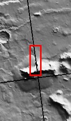
This image shows a landslide along a portion of a ridge in Promethei Terra. Landslides have very characteristic morphologies on Earth, which they also display on Mars. These morphologies include a distinctive escarpment at the uppermost part of the landslide--called a head scarp (seen at the bottom of this image), a down-dropped block of material below that escarpment that dropped almost vertically, and a deposit of debris that moved away from the escarpment at high speed. In this example, the wall rock displayed in the upper part of the cliff contains spurs and chutes created by differing amounts of erosion. The actual landslide deposit shows transverse ribs which are probably compressional features created upon emplacement of the landslide material. This image also contains a smoother plains member located in the upper part of the image and a somewhat rougher less cratered unit located below the smoother plains. This rougher unit is actually a debris apron surrounding the ridge (see context image). There are also what appear to be older more degraded landslide scars visible along the eastern portion of this ridge.
Image Credit:
NASA/JPL/Arizona State University

Image Addition Date:
2002-08-05