- Original Caption Released with Image:
-

(Released 18 July 2002)
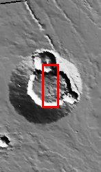
It is helpful to look at the context for this THEMIS image, which covers a large area over the summit of Ulysses Patera. Ulysses Patera is one of the many volcanoes that make up the giant Tharsis volcanic province, although Ulysses itself is fairly small in comparison to the other volcanoes in this area. In the context image, there are 3 circular features near the top of the volcano. The large, central feature is called a "caldera," and is the result of volcanic activity at Ulysses. The other two circular features are impact craters. The THEMIS image primarily spans across the central caldera, but also covers a portion of the northernmost impact crater. We know that the large central caldera must have formed earlier than the two craters, because its circular form has been cut by the smaller crater rims.In the THEMIS image, there are stair-stepping plateaus in the northern portion of the image. These are part of the rim of the northern crater, and are caused by collapse or subsidence after the impact event. Just to the south of this crater, "rayed" patterns can be seen on part of the caldera floor. The rayed pattern is most likely due to a landslide of material down the crater rim slope. Another possibility is that the impact that formed the northern crater caused material to be ejected radially, and then parts of the ejecta have either been buried or eroded away. Other signs of mass movement events in this image are dark streaks, caused by dust avalanches, visible in the caldera's northern wall. In the central portion of the image, there are two lobe-shaped features-one overlaps the other-that appear to have flowed westward. It is likely that these features are ejecta lobes, because they are located adjacent to the southeastern crater (see context image). The fluidized appearance of these ejecta lobes is probably due to a significant amount of ice or water being present in the soil at the time of impact. We know that the southeastern crater must have formed after the northern crater, because the fluidized ejecta lobe overlies the rayed pattern. A close-up look at the fluidized ejecta lobes reveals a different surface "texture" than the surrounding caldera floor. This could be due to compressional features that formed during the lobe emplacement, or to contrasting surface properties that cause the flows to be eroded differently than the caldera floor. In the lower portion of the image, there is a cluster of small circular features in the southernmost part of the central caldera. These features may be layered material that has since been eroded into circular plateaus, or they may be degraded volcanic cones, which would indicate a later stage of smaller-scale volcanism within the caldera. Volcanic cones are common in many calderas on Earth, and are formed after the initial stage of volcanic activity in that caldera. Finally, in the southern wall of the caldera, there is classic "spur-and-gully" morphology. This type of morphology is often formed on steep slopes, where variations in wall resistance cause the surface to be eroded more easily in some areas.
- Image Credit:
-
NASA/JPL/Arizona State University
Image Addition Date: -
2002-07-22
|

