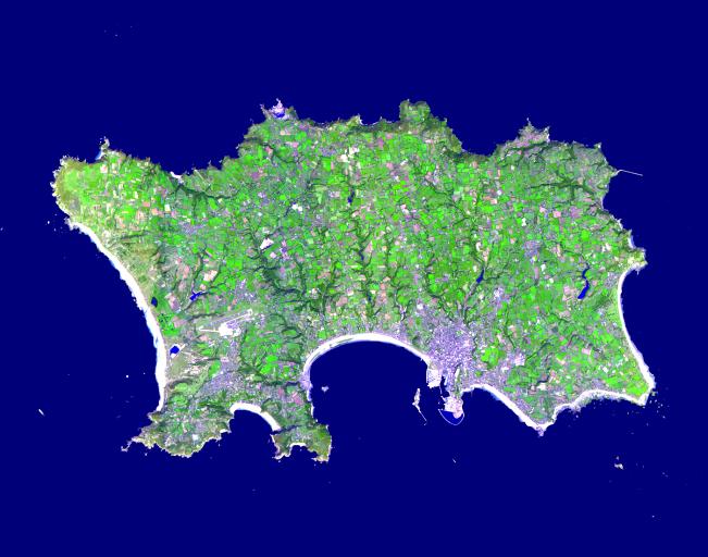
The Isle of Jersey (officially called the Bailiwick of Jersey) is the largest Channel Island, positioned in the Bay of Mont St Michel off the north-west coast of France. The island has a population of about 90,000, and covers about 90 square kilometers. The economy is based largely on international financial services, agriculture, and tourism. Called Caesaria in Roman times, Jersey becaame part of the Duchy of Normandy in 912. When William the Conqueror invaded and took the throne of England in 1066, the fortunes of Jersey then became linked to those in England, although the island manages its internal affairs through its own parliament, the States of Jersey. This image was acquired on September 23, 2000 by the Advanced Spaceborne Thermal Emission and Reflection Radiometer (ASTER) on NASA's Terra satellite. With its 14 spectral bands from the visible to the thermal infrared wavelength region, and its high spatial resolution of 15 to 90 meters (about 50 to 300 feet), ASTER images Earth to map and monitor the changing surface of our planet.
ASTER is one of five Earth-observing instruments launched December 18, 1999, on NASA's Terra satellite. The instrument was built by Japan's Ministry of Economy, Trade and Industry. A joint U.S./Japan science team is responsible for validation and calibration of the instrument and the data products.
The broad spectral coverage and high spectral resolution of ASTER will provide scientists in numerous disciplines with critical information for surface mapping, and monitoring of dynamic conditions and temporal change. Example applications are: monitoring glacial advances and retreats; monitoring potentially active volcanoes; identifying crop stress; determining cloud morphology and physical properties; wetlands evaluation; thermal pollution monitoring; coral reef degradation; surface temperature mapping of soils and geology; and measuring surface heat balance.
Dr. Anne Kahle at NASA's Jet Propulsion Laboratory, Pasadena, California, is the U.S. Science team leader; Bjorn Eng of JPL is the project manager. The Terra mission is part of NASA's Earth Science Enterprise, a long- term research effort to understand and protect our home planet. Through the study of Earth, NASA will help to provide sound science to policy and economic decision-makers so as to better life here, while developing the technologies needed to explore the universe and search for life beyond our home planet.
Size: 16.5 x 21 km (10.2 x 13 miles)
Location: 40.7 deg. North lat., 111.9 deg. West long.
Orientation: North at top
Image Data: ASTER bands 1,2, and 3.
Original Data Resolution: 15 m
Date Acquired: September 23, 2000
 Planetary Data System


