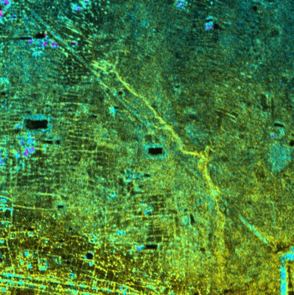
This image shows the Old Khmer Road (Inrdratataka-Bakheng causeway) in Cambodia extending from the 9th Century A.D. capitol city of Hariharalaya in the lower right portion of the image to the later 10th Century AD capital of Yasodharapura. This was located in the vicinity of Phnom Bakheng (not shown in image). The Old Road is believed to be more than 1000 years old. Its precise role and destination within the "new" city at Angkor is still being studied by archeologists. But wherever it ended, it not only offered an immense processional way for the King to move between old and new capitols, it also linked the two areas, widening the territorial base of the Khmer King. Finally, in the past and today, the Old Road managed the waters of the floodplain. It acted as a long barrage or dam for not only the natural streams of the area but also for the changes brought to the local hydrology by Khmer population growth.
The image was acquired by NASA's Airborne Synthetic Aperture Radar (AIRSAR). Image brightness is from the P-band (68 cm wavelength) radar backscatter, which is a measure of how much energy the surface reflects back towards the radar. Color is used to represent elevation contours. One cycle of color represents 20 m of elevation change, that is going from blue to red to yellow to green and back to blue again corresponds to 20 m of elevation change. Image dimensions are approximately 3.4 km by 3.5 km with a pixel spacing of 5 m. North is at top.
AIRSAR flies aboard a NASA DC-8 based at NASA's Dryden Flight Research Center, Edwards, Calif. In the TOPSAR mode, AIRSAR collects radar interferometry data from two spatially separated antennas (2.6 meters, or 8.5 feet). Information from the two antennas is used to form radar backscatter imagery and to generate highly accurate elevation data. Built, operated and managed by JPL, AIRSAR is part of NASA's Earth Science Enterprise program. JPL is a division of the California Institute of Technology in Pasadena.