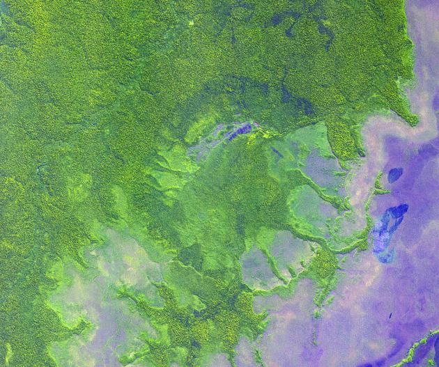
NASA scientists will venture into an isolated part of the Bolivian Amazon to try and uncover the origin of a 5 mile (8 kilometer) diameter crater there known as the Iturralde Crater. Traveling to this inhospitable forest setting, the Iturralde Crater Expedition 2002 will seek to determine if the unusual circular crater was created by a meteor or comet. Organized by Dr. Peter Wasilewski of NASA's Goddard Space Flight Center, Greenbelt, Md., the Iturralde Crater Expedition 2002 will be led by Dr. Tim Killeen of Conservation International, which is based in Bolivia. Killeen will be assisted by Dr. Compton Tucker of Goddard. The team intends to collect and analyze rocks and soil, look for glass particles that develop from meteor impacts and study magnetic properties in the area to determine if the Iturralde site was indeed created by a meteor.
This image was acquired on June 29, 2001 by the Advanced Spaceborne Thermal Emission and Reflection Radiometer (ASTER) on NASA's Terra satellite. With its 14 spectral bands from the visible to the thermal infrared wavelength region, and its high spatial resolution of 15 to 90 meters (about 50 to 300 feet), ASTER will image Earth for the next 6 years to map and monitor the changing surface of our planet.
ASTER is one of five Earth-observing instruments launched December 18, 1999, on NASA's Terra satellite. The instrument was built by Japan's Ministry of Economy, Trade and Industry. A joint U.S./Japan science team is responsible for validation and calibration of the instrument and the data products.
The broad spectral coverage and high spectral resolution of ASTER will provide scientists in numerous disciplines with critical information for surface mapping, and monitoring dynamic conditions and temporal change. Example applications are: monitoring glacial advances and retreats; monitoring potentially active volcanoes; identifying crop stress; determining cloud morphology and physical properties; wetlands evaluation; thermal pollution monitoring; coral reef degradation; surface temperature mapping of soils and geology; and measuring surface heat balance.
Dr. Anne Kahle at NASA's Jet Propulsion Laboratory, Pasadena, California, is the U.S. Science team leader; Bjorn Eng of JPL is the project manager. The Terra mission is part of NASA's Earth Science Enterprise, a long-term research and technology program designed to examine Earth's land, oceans, atmosphere, ice and life as a total integrated system.
Size: 17.9 x 15.0 km (11.1 x 9.3 miles)
Location: 12.7 deg. South lat., 67.7 deg. West long.
Orientation: North at top
Image Data: ASTER bands 1,2, and 3.
Original Data Resolution: 15 m
Date Acquired: June 29, 2001
 Planetary Data System


