PDS logoPlanetary Data System
PDS Information
Find a Node - Use these links to navigate to any of the 8 publicly accessible PDS Nodes.

This bar indicates that you are within the PDS enterprise which includes 6 science discipline nodes and 2 support nodes which are overseen by the Project Management Office at NASA's Goddard Space Flight Center (GSFC). Each node is led by an expert in the subject discipline, supported by an advisory group of other practitioners of that discipline, and subject to selection and approval under a regular NASA Research Announcement.
Click here to return to the Photojournal Home Page Click here to view a list of Photojournal Image Galleries Photojournal_inner_header
Latest Images  |  Spacecraft & Technology  |  Animations  |  Space Images App  |  Feedback  |  Photojournal Search  

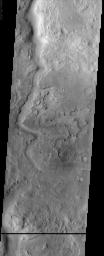
PIA03846: Huo Hsing Vallis
 Target Name:  Mars
 Is a satellite of:  Sol (our sun)
 Mission:  2001 Mars Odyssey
 Spacecraft:  2001 Mars Odyssey
 Instrument:  THEMIS
 Product Size:  1212 x 3007 pixels (w x h)
 Produced By:  Arizona State University
 Producer ID:  20020712A
 Full-Res TIFF:  PIA03846.tif (1.691 MB)
 Full-Res JPEG:  PIA03846.jpg (434.1 kB)

Click on the image above to download a moderately sized image in JPEG format (possibly reduced in size from original)

Original Caption Released with Image:


(Released 12 July 2002)
This image shows another example of an ancient channel in the Arabia Terra region of Mars. As with other channels observed on Mars, the geomorphology of Huo Hsing Vallis is suggestive of, and assumed to have been carved by, running water, although the fluid that flowed through these channels cannot be proven to have been water. This channel cuts through several layers of rocks. These rock layers may be sedimentary, composed of particles of other rocks that have been cemented together somehow, or they may be igneous layers, formed by the repeated eruption of lava (or some combination of sedimentary and igneous layers). The distinctive appearance of this terrain has led to its being described as "etched." Because the channel cuts through these rocks, the layered rocks must be older than the channel (see previous discussion of superposition). At the lower left side of the image, several intersecting ridges can be seen. These ridges may be inverted topography, or they may be exposed dikes, which form by linear intrusions of lava into rock underground; dikes are exposed by erosion of the overlying rock. The most recent activity in the region appears to be the formation of mega-ripples in the channel. Wind moving particles of rock forms these ripples perpendicular to the wind direction.
Image Credit:
NASA/JPL/Arizona State University

Image Addition Date:
2002-07-15