PDS logoPlanetary Data System
PDS Information
Find a Node - Use these links to navigate to any of the 8 publicly accessible PDS Nodes.

This bar indicates that you are within the PDS enterprise which includes 6 science discipline nodes and 2 support nodes which are overseen by the Project Management Office at NASA's Goddard Space Flight Center (GSFC). Each node is led by an expert in the subject discipline, supported by an advisory group of other practitioners of that discipline, and subject to selection and approval under a regular NASA Research Announcement.
Click here to return to the Photojournal Home Page Click here to view a list of Photojournal Image Galleries Photojournal_inner_header
Latest Images  |  Spacecraft & Technology  |  Animations  |  Space Images App  |  Feedback  |  Photojournal Search  

PIA03844: Deuteronilus Mensae
 Target Name:  Mars
 Is a satellite of:  Sol (our sun)
 Mission:  2001 Mars Odyssey
 Spacecraft:  2001 Mars Odyssey
 Instrument:  THEMIS
 Product Size:  1172 x 3007 pixels (w x h)
 Produced By:  Arizona State University
 Producer ID:  20020708A
 Full-Res TIFF:  PIA03844.tif (1.704 MB)
 Full-Res JPEG:  PIA03844.jpg (450.6 kB)

Click on the image above to download a moderately sized image in JPEG format (possibly reduced in size from original)

Original Caption Released with Image:


(Released 8 July 2002)
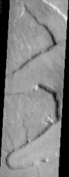
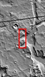
This THEMIS visible image shows several "fretted" channels within Deuteronilus Mensae in the northern plains of Mars. These linear troughs appear to have been extensively modified by surficial processes. Their floors contain knobby or "scabby" materials that have been modified to produce a pitted, knobby surface. This type of surface is common in the northern highlands of Mars, and its location and pitted texture has been suggested to indicate that these materials once contained ice that has since been removed to form the pits (devolatization). Many of the sloping surfaces in this region image have unusual deposits of material that occur preferentially on the cold, north-facing slopes. These deposits are seen frequently at mid-northern and southern latitudes, and have a distinct, rounded boundary that typically occurs at approximately the same distance below the ridge crest. It has been suggested that these deposits once draped the entire surface and have since been removed from all but the north-facing slopes. In some regions these deposits have ridges that parallel the cliff, suggestive of downslope movement and compression, possibly aided by ice. In some areas these slope deposits are darker than the material on the floor of the channel, and appear to sit on top of the pitted channel-floor materials. This relationship indicates that the slope materials have slightly different properties, leading to their darker tone, and are younger (and thus on top of) the channel floors. The presence of water ice in the surface in this area is a likely possibility to account for many of the features observed. This ice may still be present near the surface and this region may still be undergoing modification today.
Image Credit:
NASA/JPL/Arizona State University

Image Addition Date:
2002-07-08