- Original Caption Released with Image:
-

(Released 28 June 2002)
The Science
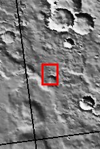
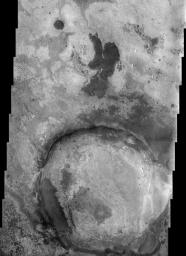
This THEMIS visible image illustrates the complex terrains within Terra Meridiani. This general region is one of the more complex on Mars, with a rich array of sedimentary, volcanic, and impact surfaces that span a wide range of martian history. This image lies at the eastern edge of a unique geologic unit that was discovered by the Mars Global Surveyor Thermal Emission Spectrometer (TES) Science Team to have high concentrations of a unique mineral called grey (crystalline) hematite. As discussed by the TES Science Team, this mineral typically forms by processes associated with water, and this region appears to have undergone alteration by hydrothermal (hot water) or other water-related processes. As a result of this evidence for water activity, this region is a leading candidate for further exploration by one of NASA's upcoming Mars Exploration Rovers. The brightness and texture of the surface varies remarkably throughout this image. These differences are associated with different rock layers or ?units?, and can be used to map the occurrence of these layers. The number of layers indicates that extensive deposition by volcanic and sedimentary processes has occurred in this region. Since that time, however, extensive erosion has occurred to produce the patchwork of different layers exposed across the surface. Several distinct layers can be seen within the ~20 km diameter crater at the bottom (south) of the image, indicating that this crater once contained layers of sedimentary material that has since been removed. THEMIS infrared images of this region show that many of these rock layers have distinctly different temperatures, indicating that the physical properties vary from layer to layer. These differences suggest that the environment and the conditions under which these layers were deposited or solidified varied through time as these layers were formed.
The Story
Mars exploration is all about following the signs of past or present water on the red planet. That's because water is the key to understanding the history of the Martian environment (climate and geology), the potential for life to have developed there, and the potential for human exploration some day far in the future. All of the missions in the Mars Exploration Program contribute something special to science investigations about water on Mars and complement each other nicely.
For instance, take the above image. Given the contrasts, you can tell that this area is pretty complex. You've got a really old crater that's been eroded, and a rich array of volcanic surfaces and layers where material has been deposited through other processes. Now, that might make this area seem like any number of images you've already seen, but this terrain holds special appeal.
A science instrument on the Mars Global Surveyor spacecraft recently discovered that this area has really high concentrations of a unique mineral called grey (crystalline) hematite. That discovery was REALLY exciting to scientists, because hematite found on Earth typically develops in the presence of water. So, did this region have water on the surface long enough for the mineral to have formed sometime in the past? And if so, could that water have been around long enough for life to have developed at some point? After all, if water was around long enough for this mineral to have formed, then maybe, just maybe . . . .
Studies of this area by Odyssey and Mars Global Surveyor are helping to pave the way for the Mars Exploration Rovers, which are scheduled to land on Mars in 2004. This alluring, hematite-rich area above is called Terra Meridiani, and is one of the leading candidates among potential landing sites. At least one of the rovers may end up exploring this very terrain! While the rover won't have instruments for detecting signs of past or present life, it will be able to use its science instruments to study the rocks up close and to determine better under what environment conditions they formed. By comparing the rover's surface data with the orbital data, scientists will be able to refine their understanding of the area. Depending on what a rover finds if it lands there, who knows what the long line of future missions to this area might look like?
In the meantime, the above THEMIS image will give scientists more opportunities to study this exciting area right now. The brightness and texture of the surface varies remarkably throughout. That's because different rock layers settled on top of one another through a long history of changing environmental conditions before extensive erosion came along to strip layers unevenly away. That's what has produce the patchwork of different exposed layers seen above. Perhaps one layer formed during a wet period of history, and then another layer formed on top of it because of volcanic activity, and then another through wind deposits. Or some other combination. Any future rover fortunate enough to go here will have a field day, as it could potentially study them all!
THEMIS's concurrent analyses in the infrared also help in understanding the sequence of layering events through time. THEMIS's infrared studies essentially measure the temperatures of all of the rock layers. Not surprisingly, it turns out that they all have varying temperatures, indicating that the physical properties also differ from layer to layer. By mapping what type of material occurs where, scientists can add to their knowledge of climatic and geologic change through time . . . and maybe have even more to say on the question of water!
- Image Credit:
-
NASA/JPL/Arizona State University
Image Addition Date: -
2003-04-09
|

 Planetary Data System


