- Original Caption Released with Image:
-
(Released 27 June 2002)
The Science
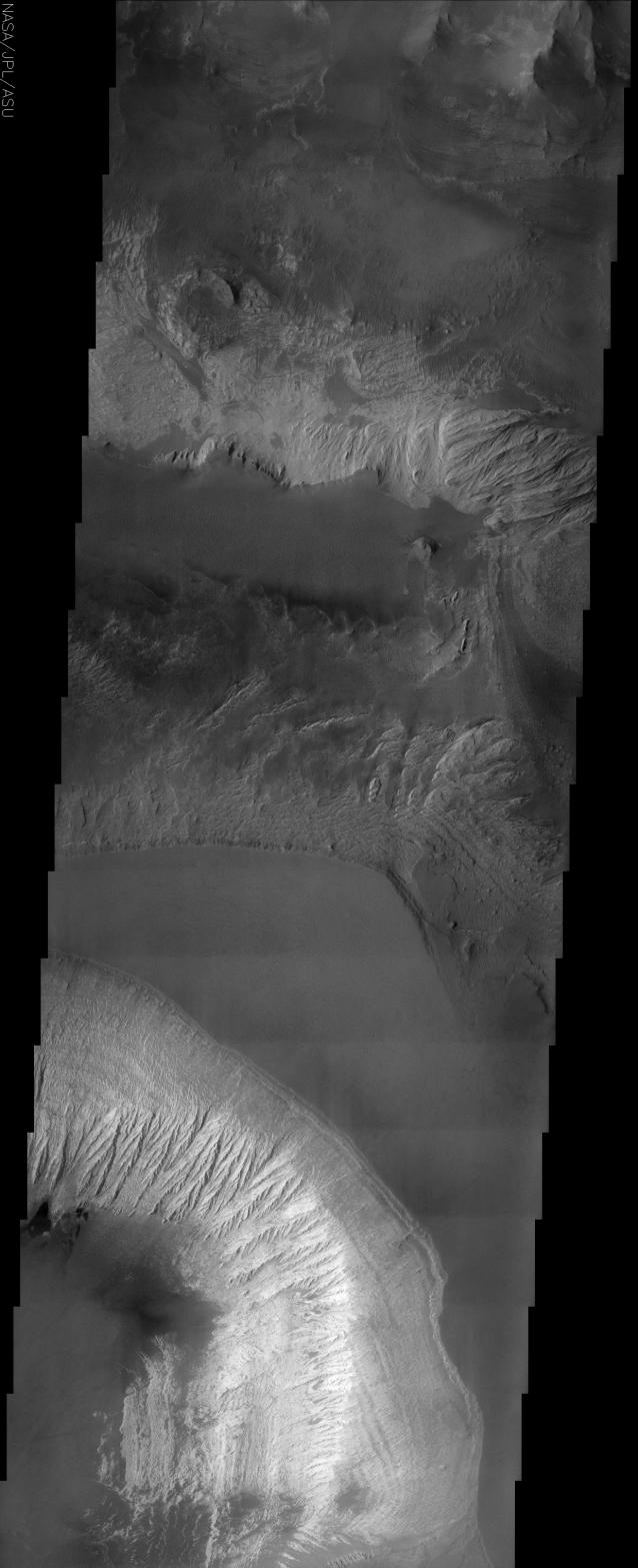
This THEMIS visible image shows the effects of erosion on a beautiful sequence of dramatically layered rocks within Candor Chasma, which is part of the Valles Marineris. These layers were initially deposited within Candor, and have subsequently been eroded by a variety of processes, including wind and downslope motion due to gravity. The effect of erosion is manifest differently in the different layers and at different locations within the layered material. For example, the upper portion of the Candor deposit seen in the lower one-third of the image appears more intact, whereas downslope there is pronounced fluting to create produced "spur and gully" slopes. Relatively dark materials are seen throughout the image and appear to mantle select areas of the layered deposits. When seen in other areas by THEMIS, and at higher resolution by the Mars Global Surveyor camera, these dark materials often form sand dunes. The dark mantling material in Candor is likely dark sand as well. Several particularly dark patches can be seen near the left (western) edge of the image, approximately one quarter of the way up from the bottom of the image. Very few impact craters of any size can be seen in this image, indicating that the erosion and transport of material is occurring at a relatively rapid rate, so that any craters that form are rapidly buried or eroded.
The Story
The smooth, triangular shape near the center of this image is the plateau of a canyon, with walls that dramatically descend on either side. This canyon is named Chasma, which means "blaze" or "white" in Latin. The lighter, brighter material of the southern canyon wall displays erosional streaks that almost do happen to look like a white blaze.
Toward the bottom left of the image, you can see how the relatively brighter material from the top has been carried down to the bottom. Notice that the upper, grayer part of the southern canyon walls don't seem to have the same erosional flutes as the brighter material just below it. By looking at such differences on the same canyon wall, geologists can begin to understand the kinds of materials that make up each layer of the canyon wall, and how resistant each is to erosion.
No matter what part of the canyon you look at, erosion has created the beautiful sequence of layered rocks within Candor. Sometimes it's the wind that acts, and sometimes gravity, which pulls material from the upper parts of the canyon downslope. Be sure to click on the above image for a close-up view of all of the subtle layers and ripples.
Look also for some dark, almost black patches (bottom left, about a quarter of the way up). These dark splotches are most likely made of sand. In fact, much of the darker areas seen in this image are probably made of sand. The sand often forms in dunes, as both THEMIS and the higher resolution camera on Mars Global Surveyor, Odyssey's sister orbiter, have shown.
With all of the wind and downslope erosion, this area is fairly active geologically. You can tell because there are very few impact craters of any size to be seen. That means material is being transported at a rate that's rapid enough to bury or erode any craters that do form.
Candor Chasma is part of Valles Marineris, the large canyon system that slices across a large part of the red planet. If Valles Marineris were located on Earth, it would stretch all the way from the west coast to the east coast of the United States.
- Image Credit:
-
NASA/JPL/Arizona State University
Image Addition Date: -
2002-07-03
|
 Planetary Data System


