- Original Caption Released with Image:
-
(Released 21 June 2002)
The Science
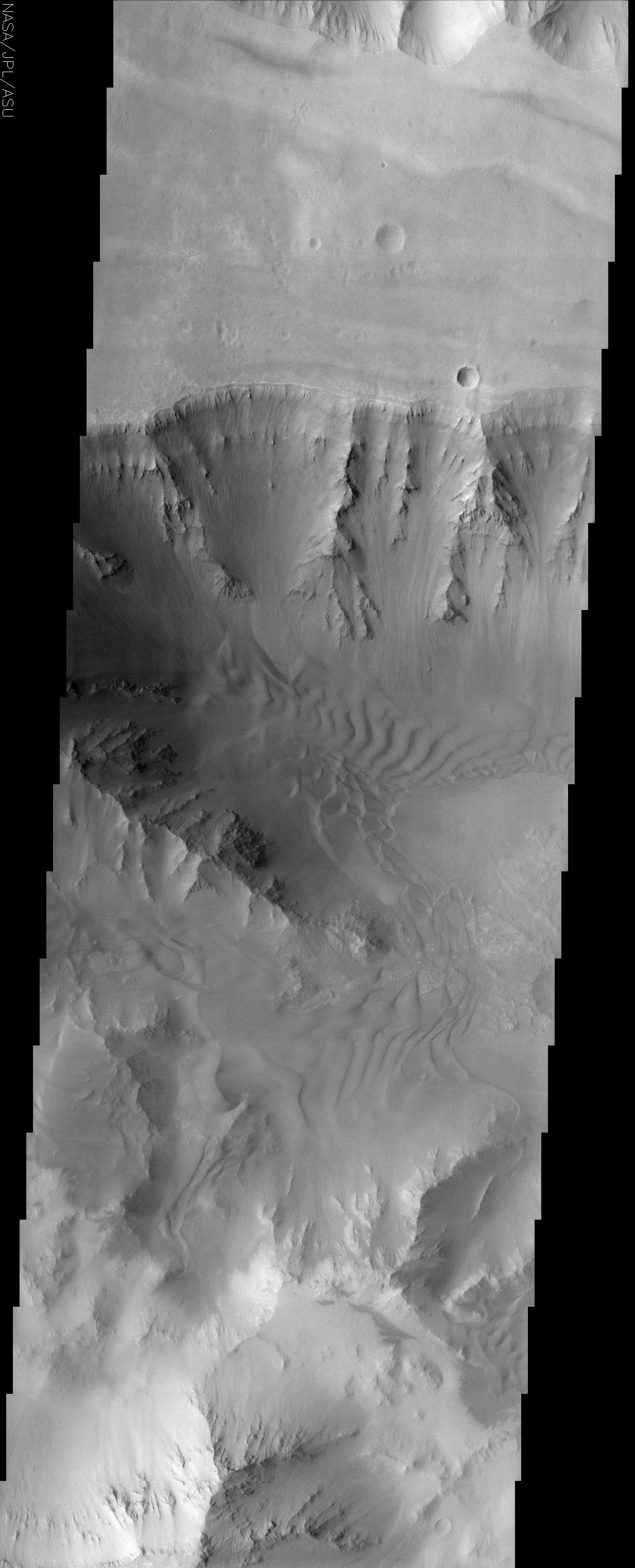
This image covers a portion of Coprates Chasma, located near 15.5S, 57.8W, which is part of the Valles Marineris system of canyons that stretch for thousands of kilometers. This image displays clearly the contrast between bedrock, sand, and dust surfaces. The steepest slopes, such as on the canyon walls, appear to be free of the mantle of dust and sand that is nearly ubiquitous elsewhere in the image. Layering is clearly present in the bedrock unit, but it is not clear if that layering is due to sedimentary deposits or volcanic lava flows. Superimposed on the slopes is a mantle of dust in a manner that appears similar to snow covered mountains on Earth. This is because in both situations, fine-grained dry, particulate material is settling on a sloped surface. Collecting in the valleys and, in some cases, climbing up the slopes are several sand sheets. The amount of cover and the apparent thickness of these sands give some indication to the huge volume of material that is collected here. The orientation of the slip faces of the dunes in this image can be used to deduce the prevalent wind patterns in the region. In this case, the prevalent wind direction is towards the east but there are areas where the winds indicate a more complex system, perhaps indicating topographic control of the local winds.
The Story
The canyon walls of Coprates, the old name for the Persian River Ab-I-Diz, descend clearly at the top of this image, without being obscured by the dust that covers much of this region. Coprates Chasma is part of Valles Marineris, the largest canyon system in the solar system.
In addition to the hard bedrock and dust, sand dunes also appear on the floor of the canyon. They almost look as though they've been raked by a Zen gardener, but the eastward-blowing wind is really responsible for their rows. Scientists can tell the direction of the wind by looking at the slip faces of the dunes -- that is, by identifying the steep, downward slope formed from loose, cascading sand. Some areas seem to have been formed by more complex wind patterns that may have emerged due to the topography of the area.
This region is, in fact, pretty complex. The sand in this area looks like it is thick and abundant. Not only has it collected in the valleys, it has also built up enough to begin to "climb up" the slopes. There is also layering in the bedrock, but who knows if this layering is made of deposits of "dirt" and rock or from lava. Finally, at the bottom of this image, dust-covered slopes appear like snow-covered mountain s on Earth. This similar look occurs because both dust and snow are fine-grained particles and cover the slopes in comparable ways.
- Image Credit:
-
NASA/JPL/Arizona State University
Image Addition Date: -
2002-06-26
|
 Planetary Data System


