- Original Caption Released with Image:
-
(Released 5 June 2002)
The Science
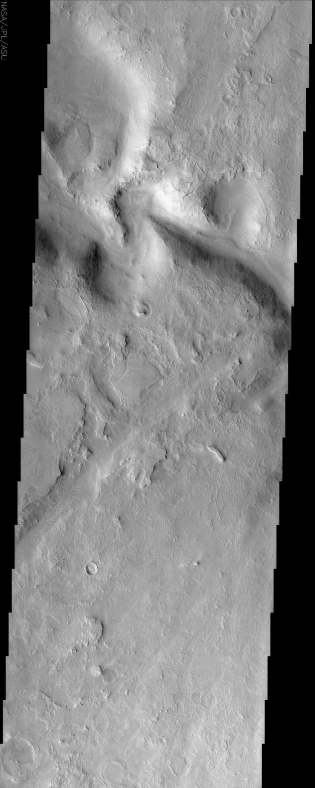
A portion of an ancient channel called the Huo Hsing Vallis seen in the center of this image. As with all channel forms on Mars, it was carved by some moving fluid but that fluid can not automatically be assumed to be water. Lava and even wind can sculpt channel forms that mimic those of flowing water. In this case, the presence of pronounced oxbow bends in the channel favors the conclusion that water was the fluid. It is interesting that the ripple-like ridges on the channel floor mimic current ripples found in many streams on Earth. But the fluid responsible for their formation likely is the wind. Similar ripples occur in many places on Mars that have no relationship to channels. Surrounding the channel is an intensely eroded landscape known as etched terrain. The many layers that were deposited in the past are now being eroded away by the wind. In the process, unusual polygonal ridges are being exposed, the most prominent of which appear just north of the oxbow bends. The mechanism by with they form is poorly understood. It is possible that they began as polygonal troughs similar in form and origin as those that form in permafrost regions on Earth like the Canadian Arctic. If the troughs were subsequently filled in by sediment that solidified into a more resistant deposit than the surrounding material, later erosion would leave behind ridges in place of the former troughs. Known as inverted topography, there are examples of this type of landform in other etched terrains on Mars.
The Story
For thousands of years, many cultures the world over have studied the planets, first by observing their motions in the night sky, later through telescopes, and today through up-close observation enabled by spacecraft. Many places on Mars are given names that honor the long history of contributions by all peoples to Mars exploration. Huo Hsing, the Chinese word for the planet Mars, is the namesake of the ancient channel shown above.
As with all channel forms on Mars, it was carved by a moving fluid. Sometimes the moving fluid that created the channels can be identified as water, sometimes as lava, and sometimes as something else entirely. Even the wind can carve out the terrain in grooves. So, how can you tell what force split the smoothness of the land? In this case, check out the tight, meandering loops called oxbow bends. This pattern suggests that water was the mysterious fluid. We frequently see such bends in rivers and floodplains on Earth.
At the bottom of the empty channel, you can see rippling ridges. This undulating terrain is a dry mimic of the waves that once rippled on currents down the channel, but it wasn't water that shaped these landforms. They were created by the wind and occur not only in Martian channels, but all over the windswept red planet.
Wind erosion is a geologist's friend, because it can uncover a planet's deeper secrets. What you can see all around the deeper channels is a terrain that seems almost "flaky" in appearance. It's known as etched terrain and is created by the wind as it scours the planet again and again over the years, unevenly eroding the surface. The coolest thing in this image is that the wind has eroded enough material just north of the oxbow bends to reveal a crackly-patterned surface known as polygonal ridges.
Why is that so interesting? While no one knows exactly how they formed, it's possible that they began as polygonal troughs similar to those that form in permafrost regions on Earth like the Canadian Arctic. At least on Earth, the formation of these polygons are directly linked to the repeated thawing and freezing of water and the stresses that puts on the surface. That gives scientists a further indication that water could have been more than an occasional force in molding this region. Whether water was the original culprit or not, it's wind that has taken over.
You'll notice that while these "crackly features" may have begun as troughs, their polygonal edges sure seem like they're slightly raised above the surrounding terrain. And they are! It's possible that the former troughs were filled in at some point by a strong, erosion-resistant deposit that eventually solidified over time. As the wind continued to shave away the surrounding terrain, ridges were left behind. These ridges are known as inverted topography, and occur in many etched terrains on Mars.
- Image Credit:
-
NASA/JPL/Arizona State University
Image Addition Date: -
2002-06-17
|
 Planetary Data System


